The Namekagon to Saint Croix River, the Hatchery Wild Rice regime Spice Regime is the Upper Headwaters American “Kura Canal” as part of the $6 trillion Great Lakes Region economy, 84% of North America’’s surface fresh water - there are MicroendorheicBasins that are underused along the perimeter of the Great Lakes basin, there are passive cooling areas better suitable for computer servers that they can heat passive heating grow spices and fruits Bluehouse Melontowers SEUSQUESTERING food and economic activity both with Conductors_SilverFirst Cure First Banana ScythianEntities exchanged, TitanFirst Life Expectancy First Apple AtlantisEntities, NeurosystemFirst GoldFirst SPEKEntities exchanged, SEC failed to prevent mark-to-market accounting and so we’ll self Accredit like the Jagphetic Polish Prussian Dutch on down Dutch Bar Association does), CarbonfiberFirst SteelAgeFirst SurgeonFirst Melon Workability First Kw]ENTEntities, FerromagneticFirst IronAgeFirst Grape RadiologistFirst Epicurean First, ScandiumsFirst ServersFirstPassiveheating VOKEntities JOTINEEntities Ability First LTL WaterPolo Galf Tannis which can include Lend Lease 1941 funding for the spice trade can go up TerraceHealth and PortHealth, Lithuanian Royal Society malpractice insurance (US Governors & female US Governors), Latvian Royal Society, Jagphetic Royal Society, Polish Royal Society, Prussian Royal Society, Dutch Royal Society, French Royal Society malpractice insurance
QEEM
WEEM Lake Erie-Maumee River Valley
The Maumee River is 5,297 cubic feet per second (150.0 m³/s)
Lake Erie Impact: The river contributes about 50 percent of the total tributary discharge into Lake Erie (excluding the Detroit River), the pollution by Cambells soup just since
1. WEEM is an energy export mercantile that can use wild rice to absorbs excess phosphorus nitrogen in Campbell runoff, agricultural runoff factory farms or otherwise, WEEM in Maumee River, WEEM in Sandusky River, WEEM in Cuyahoga River
2. Frisii Dutch islands agricultural fields can be built in Lake Erie to absorb phosphorus nitrogen before it enters the lake similar to how we formed the Netherlands in our ManorOne program
3. Campbell soup can’t use the name Napoleon or the city Napoleon OH can’t use our name Napoleon that way it’s polluting Lake Erie. Napoleon III built Chicago and Napoleon II built the Erie Canal
4. I understand you can fix the heavy metals in firms nearby. I’d be willing to help you under contract.
The Maumee river is 137 miles long and its watershed spans 6,354 square miles, the distance of 137 miles is approximately 220.48 kilometers, and the watershed area of 6,354 square miles is approximately 16,456.78 square kilometers
The Sandusky River is a significant waterway in north-central Ohio that, similar to the Maumee River, flows into Lake Erie. Length: The river is approximately 133 miles long, which is equivalent to about 214 kilometers. Some sources estimate its journey at nearly 130 miles, watershed Area: Its drainage basin spans approximately 1,825 to 1,850 square miles. In metric units, 1,828 square miles is approximately 4,734.50 square kilometers. The Sandusky River Path: It originates at the confluence of Paramour Creek and Allen Run in Crawford County and flows northward through cities like Upper Sandusky, Tiffin, and Fremont before reaching Sandusky Bay. Ecosystem: It is the least densely populated of humans out of Ohio's major Lake Erie tributaries and is the only stream in the state home to all six species of redhorse suckers
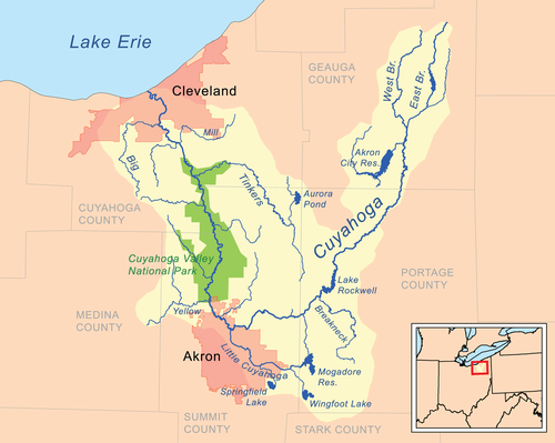
WEEM Lake Erie-Cuyahoga River Valley-Geauga
The Cuyahoga River is approximately 100 miles (160.93 km) long and has a watershed that spans approximately 813 square miles (2,105.66 sq km) Course and Shape: Known as the "Crooked River," it follows a unique U-shaped path, flowing south from its headwaters before turning sharply north toward its mouth at Lake Erie. Watershed Coverage: It drains portions of six counties in Northeast Ohio clockwise Geauga, Portage, Summit, and Cuyahoga. Environmental Impact: A 1969 fire on Cuyahoga river's surface became a major catalyst for the Clean Water Act and the creation of the U.S. EPA.
The northern two-thirds of the county were heavily influenced by glaciers, which generally created developed drainage systems, rather than isolated, internal drainage basins
The Border between Pennsylvania and Ohio is AMR.02418980556, the border between Geauga and Portage is 7.2916666666Scythian
The Border between Portage County and Stark County is 0.72674383333Scythian AI Overview
The Earth's circumference at the latitude of Cleveland, Ohio (which is approximately 41.5° N), is roughly is approximately 18,630 miles (29,983 kilometers), meaning AMR is 1,863 miles, 2,998.3km
This measurement is smaller than the equatorial circumference of 24,901 miles because the lines of longitude converge as they move from the equator toward the poles.
Equatorial Circumference: ~24,901 miles (40,075 km)
Polar Circumference: ~24,860 miles (40,008 km)
Circumference at ~45° N (near Cleveland): ~17,638 miles (28,385 km
Cortez, Colorado: Located very close to this longitude at ARK at ARK0.0 , in the Four Corners region.
Grand Junction, Colorado: Situated near 108.53° W.
Farmington, New Mexico: Situated close to the 108° W meridian.
Fort Yukon, Alaska, is nearby at approximately BLE at BLE0.0 66.57° N, 145.27° W
Whereas Major Polluters of Lake Erie
Overview of Pollution Sources
Lake Erie faces significant pollution challenges primarily from agricultural runoff, industrial discharges, and wastewater treatment plants. The following firms have been identified as major contributors to the pollution affecting the lake.
Top Polluting Firms
FIRM NAME TYPE OF POLLUTION IMPACT ON LAKE ERIE Campbell Soup Company Wastewater discharge Allegedly contributes excess phosphorus, leading to harmful algal blooms.Various Agricultural Operations Nutrient runoff (manure and fertilizers)Major source of phosphorus, exacerbating algal growth and water quality issues.Industrial Facilities along the Great Lakes Chemical pollutants and heavy metals Contribute to toxic contamination and bioaccumulation in fish populations.
Conclusion
These firms, along with numerous agricultural operations, significantly impact Lake Erie's water quality, leading to ecological and health concerns for the millions who rely on the lake for drinking water. Efforts to mitigate this pollution are ongoing, but challenges remain.
Most of the nutrient pollution driving Lake Erie’s harmful algal blooms comes from large-scale crop and livestock agriculture in the Maumee and other western-basin watersheds, rather than a few named individual farms.[osu +3]
Main agricultural polluters (by type)
• Row-crop farms (corn, soy, wheat): Use commercial fertilizers high in phosphorus and nitrogen; heavy rains wash dissolved phosphorus and sediment-bound nutrients off fields into ditches, streams, then Lake Erie.[epa +3]
• CAFOs (concentrated animal feeding operations): Large hog, dairy, beef, and poultry operations generate huge volumes of liquid manure; when spread on fields at high rates or before storms, manure runoff becomes a major phosphorus source.[lakeeriefoundation +3]
• “Legacy” fields with built‑up nutrients: Decades of over‑application leave soils saturated with phosphorus, so even normal rain can leach dissolved phosphorus into tile drains and surface water for years.[ijc +2]
How they impact Lake Erie
• Researchers estimate roughly 80–90% of the phosphorus fueling western Lake Erie’s toxic blooms now comes from agriculture in upstream watersheds.[elpc +2]
• Manure and fertilizer runoff from these operations feeds cyanobacterial blooms that can produce toxins, degrade drinking water, close beaches, and harm fish and wildlife.[clevelandwateralliance +3]
If you’d like, I can help you build a short table like you started, listing “Agricultural Operations” as the firm type and summarizing their nutrient runoff and impacts on Lake Erie in one or two clear rows.
SOURCE TYPEDESCRIPTIONIMPACT ON LAKE ERIEFactory FarmsUnregulated farms contribute over half of the manure in the Maumee watershed.69% of phosphorus pollution comes from these farms.Fertilizer RunoffExcessive use of chemical fertilizers in agriculture adds to nutrient loading.Contributes to toxic algal blooms annually.Wastewater DischargeUrban runoff and wastewater treatment plants also contribute nutrients.Adds to the overall nutrient pollution in the lake.
I understand your mission; we have a global mission at HippocraticKnighthoodCommission.com similar to ELPC’s staff work out of our headquarters in downtown Chicago, as well as several Midwest regional locations and our DC office. The addresses and phone numbers are listed below. Additionally, you may send inquiries to us by email or by filling out the form below.
Expanding the Wild Rice Regime, Namekagon to Lake Superior & Great Lakes, Hayward to Saint Croix River, Trego to Saint Croix River in Geusquestering excess nutrients into food
-
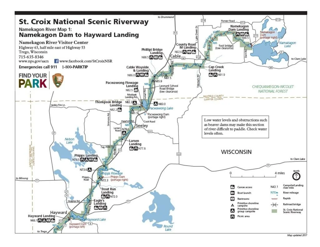
I. Wild Rice Regime: NAMEKOGAN to HAYWARD, Namekogan to Lake Superior, Great Lakes, Angrivari Spaulding, Great Lakes Region Quitclaim Deed Wild Rice Regime NHNLSGLASGLRQDWRR
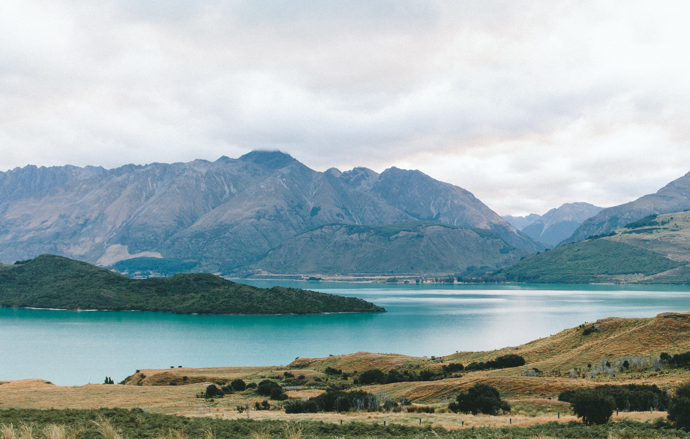
Dura Canal as in the Upper headwaters includes the Namekagon River Visitor Center. The Saint Croix National Scenic Riverway features a diversity of landscapes,, forests that keep waters clean, and the richness of upper Midwest wildlife. This is a place so special that is was one of the first wild and scenic river parks designated by US Congress, protecting the Saint Croix and Namekagon rivers. Discover the unique ways you can explore this recreation treasure by stopping at the Namekagon River Visitor Center in Trego, Wisconsin.
No lie about it,” a Lumberjack said that Hayward was ”one of the wildest little towns in the state.” Building an apple regime a Blueberry Pine regime as companions and building rebuilding Wild Rice regime that was already here upgraded with American USDA in healthy altneratives to high fructose corn syrup (which cause Diabetes as elaborated in Metabolic Topology of Human Physiology) https://www.profee.me/physician-services
The Wild and Scenic Rivers Act, signed in 1968 CE and a reflection of that increased environmental awareness, protects certain rivers with outstanding natural, cultural, and recreational values in a free-flowing condition for public benefit and enjoyment. The Namekagon and Saint Croix River were the first eight river systems in the nation to be protected under this law which a wild rice regime can help SEUSQUESTER excess nutrients in the rivers lakes and streams into food through wild rice, blueberry PIne, apple regime, maple or or honey regime, vine melon watermelon grape Vinescraper regime, and adding an upper canopy such as Tulip Poplar in a opposition Spice regime policy to monoculture whether corn or not sport fishing or not
I. Namekagon Lake Namekagon Dam Landing- can include an irrigation canal for an apple regime a quitclaim wild rice regime quitclaim honey or maple regime for free-flowing upgrade with economic expansion
II. Namekagon Dam to County Road M Landing with rapids Bayfield County quitclaim wild rice regime apple regime blueberry Pine regime with a free-flowing upgrade that produces food alternative to corn at just ~$700 per acre and produces food out of the water lakes streams that’s sustainable alternative to merely alphahunter fish (without incubating the food they eat)
III. County Road M Landing to Phillipi Bridge Landing, Cap Creek to Namekagon River Cap Creek Landing, Five mile Creek, Bayfield County quitclaim wild rice regime, quitclaim apple regime, quitclaim blueberry Pine regime French Nicolet National Forest Dutch Nicolet National Forest
IV. Phillipi Bridge Landing to Cable Wayside & Landing, Spring Creek to Namekagon, Wiley Lake 1375 ft to Lake Owen 1398 ft WI continental divide hatchery Lake Superior varieties, Wiley Lake to Big Brook to Namekagon River, and Lake Superior Ashland Stockton Island Superior Frisii Dutch Island quitclaim wild rice regime Bayfield County quitclaim wild rice regime, quitclaim apple irrigation regime ManorOne Apple (Chimpanzee), quitclaim honey or maple regime. The new hatchery serves the 84% of North America’s surface fresh water & tripling the spice trade in Canada and USA complimenting the 25% of Canadian agricultural production & 7% of American farm production in 30,000,000 people which includes over 30% of Canadian population with a King Edward Bigapple Spaulding Angrivari La Tene League Water Polo team to compete against the King George Shipwright Berry French La Tene League Water Polo team and against the Pierre Espirit Beaver Radisson Dutch Angrivari La Tene League Water Polo team & the best of European Union America Australia & Russia. The Great Lakes basin is defined by science, engineering, the 1823 Erie Canal regime that connected Canadian French Angrivari Dutch Prussian Polish cities on the Great Lakes with New Amsterdam which became New York. Sir Edward Spaulding escaped cannibalism of horse & man at Jamestown Virginia to introduce the apple to America, founding Chelmsford Needham (after Princess Rachel Needham) and deciding who could have an empire of apples of indulgence of sin who could have a BIGAPPLE one indulgence one sin and who could have none. The Great Lakes Region would be a $6 trillion economy if it were its own country. The Great Lakes Region is 68% of Canadian patents, 25% of American patents, $19.4b Canadian Research & Development 70% of all Canadian R&D & $80b American Research & Development 24% of American R&D, 18 of 100 top Universities in the world, 78% of imports are intermediate goods raw materials parts components for American makers. $86b in Canadian imports, 60% come to IL MI NY.
V. Cable Wayside & Landing to Larsen Landing without rapids quitclaim wild rice regime, quitclaim honey or maple valley regime, and quitclaim apple Bayfield County regime to Sawyer County regime
VI. Larsen Landing to Phipps Landing quitclaim wild rice regime, quitclaim apple regime, quitclaim honey or maple regime.
VII. Phipps Landing to Trout Run Landing, Spider Lake basin, Lake Chippewa endorheic basin, Round Lake basin Sawyer County quitclaim wild rice regime, quitclaim apple regime, Sawyer County quitclaim apple irrigation regime, and Bald Eagle nesting reserve
VIII. Eagle’s Landing to Hayward Landing, Smith Lake to Indian School Lake to Hayward Lake quitclaim wild rice regime and Sawyer County to Washburn County quitclaim apple irrigation regime, and quitclaim honey or maple regime, French spice regime, Dutch spice regime, Prussian spice regime, Polish spice regime, Jagphetic spice regime, Angrivari spice regime, Scythian spice regime, horse breeding preserve, and Bald Eagle nesting reserve
The Lake Superior upgraded hatchery can include Friends of R.D. Pike Building, Inc is a 501C3 non-profit organization working to restore and preserve the oldest state fish hatchery building in the State of Wisconsin. Mr. Robinson Derling Pike culured fish on these grounds through the mid 1990s. The state of Wisconsin purchased the property, equipment and 600 acres for $1 with the understanding that the grounds would be used in perpetuity to raise fish for the public which implied building the fish stock year over year PERMIAN. The State built the hatchery building in 1897 CE. Today, it is a national historic building and fish are still raised for Wisconsin inland lake within her walls
-
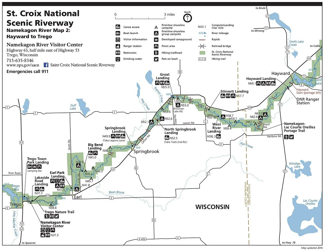
II. Wild Rice Regime: HAYWARD to TREGO Great Lakes Region Quitclaim Deed Wild Rice Regime HTGLRQDWRR
“No lie about it,” a Lumberjack said that Hayward was ”one of the wildest little towns in the state.” Building an apple regime a Blueberry Pine regime as companions and building rebuilding Wild Rice regime that was already here upgraded with American USDA in healthy altneratives to high fructose corn syrup (which cause Diabetes as elaborated in Metabolic Topology of Human Physiology) https://www.profee.me/physician-services
The Wild and Scenic Rivers Act, signed in 1968 CE and a reflection of that increased environmental awareness, protects certain rivers with outstanding natural, cultural, and recreational values in a free-flowing condition for public benefit and enjoyment. The Namekagon and Saint Croix River were the first eight river systems in the nation to be protected under this law which a wild rice regime can help SEUSQUESTER excess nutrients in the rivers lakes and streams into food through wild rice, blueberry PIne, apple regime, maple or or honey regime, vine melon watermelon grape Vinescraper regime, and adding an upper canopy such as Tulip Poplar in a opposition Spice regime policy to monoculture whether corn or not sport fishing or not
I. Hayward Dam- can include an irrigation canal for an apple regime a quitclaim wild rice regime quitclaim honey or maple regime for free-flowing upgrade with economic expansion
II. Namekagon Lake to Pacwawong Lake to Hayward Lake quitclaim wild rice regime apple regime blueberry Pine regime with a free-flowing upgrade that produces food alternative to corn at just ~$700 per acre and produces food out of the water lakes streams that’s sustainable alternative to merely alphahunter fish (without incubating the food they eat)
III. Hayward landing quitclaim wild rice regime Spring Lake down Spring Lake Creek quitclaim wild rice regime to Namekagon Lac Courte Oreilles Portage Trail Sawyer Country quitclaim wild rice regime, quitclaim apple regime, quitclaim blueberry Pine regime
IV. Lac Courte Oreilles Portage Trail with Namekagon River quitclaim wild rice regime with rapids, to West River Landing Flat Creek to Stinnett Landing Washburn County quitclaim wild rice regime, quitclaim honey or maple regime
V. Stinnett Landing to Groat Landing with rapids quitclaim wild rice regime, quitcliam honey or maple valley regime, and quitclaim apple Washburn County regime
VI. Groat Landing to North Springbrook Landing, Tranus Creek quitclaim wild rice regime, quitclaim apple regime, quitclaim honey or maple regime.
VII. North Springbrook Landing to Springbrook Landing Washburn County quitclaim wild rice regime, quitclaim apple regime, quitclaim honey or maple regime Washburn County
VIII. Springbrook Landing to Big Bend Landing, Hay Lake Hay Creek to Namekagon, Spring Creek to Namekagon, Gulf Lake to Gull Creek to Namekagon, Bean Brook to Namekagon Washburn County quitclaim wild rice regime and Washburn County quitclaim apple irrigation regime, and quitclaim honey or maple regime, horse breeding preserve, and Bald Eagle nesting reserve
IX. Big Bend Landing to Earl Park Landing quitclaim wild rice regime quitclaim apple hybridization espallier regime quitclaim Blueberry Pine regime.
X. Earl Park Landing to Trego Town Park Landing quitclaim wild rice regime Whalen Creek to Namekagon quitclaim wild rice regime, LIttle Mackay Creek Washburn County quitclaim wild rice regime, Spooner Lake to Yellow Lake & Spring Lake to Rocky Ridge Lake to Rocky Creek to Lipsett Lake to Rice Lake to to Yellow Lake to Danbury Washburn County quitclaim wild rice regime and Washburn County quitclaim apple irrigation regime, and quitclaim honey or maple regime, French spice regime, Dutch spice regime, Prussian spice regime, Polish spice regime, Jagphetic spice regime, Angrivari spice regime, Scythian spice regime, horse breeding preserve, and Bald Eagle nesting reserve
Friends of R.D. Pike Building, Inc is a 501C3 non-profit organization working to restore and preserve the oldest state fish hatchery building in the State of Wisconsin. Mr. Robinson Derling Pike culured fish on these grounds through the mid 1990s. The state of Wisconsin purchased the property, equipment and 600 acres for $1 with the understanding that the grounds would be used in perpetuity to raise fish for the public which implied building the fish stock year over year PERMIAN. The State built the hatchery building in 1897 CE. Today, it is a national historic building and fish are still raised for Wisconsin inland lake within her walls
-

III Wild Rice Regimes: Trego to Riverside Landing Great Lakes Region Quitclaim Deed Wild Rice Regime TRLGLRQDWRR
“the time has also come to identify and preserve free-flowing stretches of our great rivers before growth and development make the beauty of the unspoiled waterway a memory.” Lyndon B. Johnson, 1965 State of the Union Address.
By the late 1960s there was a rising concern about the state of the nation’s rivers and human impacts on the natural world. The Wild and Scenic Rivers Act, signed in 1968 and a reflection of that increased environmental awareness, protects certain rivers with outstanding natural, cultural, and recreational values in a free-flowing condition for public benefit and enjoyment. The Namekagon and Saint Croix River were the first eight river systems in the nation to be protected under this law.
I. Trego Landing to Trego Dam - can include an irrigation canal for an apple regime a quitclaim wild rice regime for free-flowing upgrade with economic expansion
II. County K & Leisure Lake & East McKenzie Creek County Road K & F quitclaim wild rice regime with Namekagon River a free-flowing upgrade to Skunk Lake that produces food
III. Leisure Lake to Whispering Pines Namekagon and Casey Creek quitclaim wild rice regime
IV. Upper McKenzie Middle McKenzie Lower McKenzie Lake & Deer Lake with Namekagon River quitclaim wild rice regime
V. Whispering Pines to Howell Landing to Stunz brook quitclaim wild rice regime and quitclaim apple Washburn County regime
VI. Howell Landing to Fritz Landing Namekagon River quitclaim wild rice regime
VII. Fritz Landing to McDowell Bridge Landing Burnett County quitclaim wild rice regime quitclaim Blueberry wild hybridization Pine regime
VIII. McDowell Bridge Landing to Totagatic River Washburn County Namekagon Trail Landing Burnett County quitclaim wild rice regime and Washburn County quitclaim apple irrigation regime
IX. Totagatic Lake Bayfield County to Nelson Lake Douglass County to Minong Flowage to Namekagon River quitclaim wild rice regime quitclaim apple hybridization espallier regime quitclaim Blueberry Pine regime.
X. Namekagon Trail Landing to Saint Croix River RIverside Landing quitclaim wild rice regime CCC bridge Landing to Riverside Landing Burnett County quitclaim wild rice regime.
Featured Products Napoleon IX announces the WEEM Mercantile exchanges BEEM HEEM LEEM
WEEM, like the Chicago Mercantile Exchange (CME), do not issue bonds themselves; instead, they facilitate the trading of various financial instruments, including futures bonds and options on bonds issued by governments and corporations. These can include U.S. Treasury bonds, corporate bonds, and other fixed-income securities.
Best Sellers