Gordon Dam Saint Croix River to Sand Creek to Mississippi Basin Wild Rice Regime, Rice Regime.
Make it stand out.
-

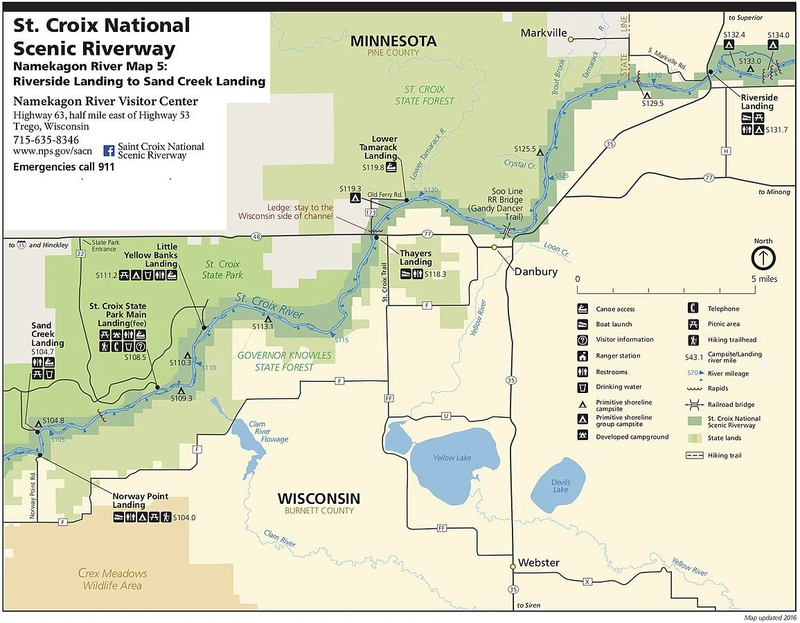
IV. Wild Rice Regime: Saint Croix River Gordon Dam to Riverside Landing Saint Croix Quitclaim Deed Wild Rice Regime SCQDWRR
A Healthy river starts with forested lands, like those surrounding the upper Saint Croix. Forest soils are natural sponges, soakingup rainwater and then filtering and cleansing it before it moves into streams or underground aquifers. This traps pollutants, like herbicides, pesticides, and excess nutrients from fertilizers, and prevents them from entering waterways. Saint Croix Wild Rice Regime SCWRR goes one step further by SEUSQUESTERING excess nutrients from agriculture or not into food. Quitclaim Deeds QD can be issued to SCWRR with a French Wildlife Refuge in a joint venture with property owners with riparian access and Saint Croix Wild Rice Regime SCWRR funding work. The French Wildlife Refuge has treaties trusts and obligations from prior to 1873 CE and is the right instrument for increasing compliance with the Wild and Scenic Rivers Act 1968 CE as they are the prior regime under French Mississippi Company building an bamboo regime, apple regime, a watermelon regime a cherry strawberry regime, a grape regime, a citron regime, a fig regime. The Blueberry Pine regime as companions to add Blueberry where pine grows as an alternative to logging & adding Pine where Blueberry is grown as a companion in acid loving plants. This building rebuilding Mississippi Valley Wild Rice Regime MVWRR beginning with Saint Croix Wild Rice Regime SCWRR that was already here upgraded with American USDA in healthy alternatives to high fructose corn syrup (which cause Diabetes as elaborated in Metabolic Topology of Human Physiology) https://www.profee.me/physician-services
The Wild and Scenic Rivers Act, signed in 1968 CE and a reflection of that increased environmental awareness, protects certain rivers with outstanding natural, cultural, and recreational values in a free-flowing condition for public benefit and enjoyment which adding wild rice fruiting trees meets and exceeds the intent of the Act. The Namekagon and Saint Croix River were the first eight river systems in the nation to be protected under this law and were the prior wild rice regime and now restored with the Saint Croix Wild Rice Regime SCWRR and the Mississippi is the largest river making it an important compliant Scenic river. This wild rice regime builds on the success of the rice in Arkansas in hybridization efforts that can help SEUSQUESTER excess nutrients in the rivers lakes and streams into food through wild rice, blueberry PIne, apple regime, maple or or honey regime, vine melon watermelon grape Vinescraper regime propped up against the Mississippi Lock and Dam in adding GDP to the investment, and adding an upper canopy such as Tulip Poplar in a opposition Spice regime policy to monoculture whether corn or not sport fishing or not
I. Upper Saint Croix Lake to Saint Croix Flowage to Gordon Dam- can include a freeflowing irrigation canal for an apple regime a quitclaim wild rice regime quitclaim honey or maple regime for free-flowing upgrade with economic expansion
II. Gordon Dam to County Road T Landing with Rapids quitclaim wild rice regime apple regime blueberry Pine regime with a free-flowing upgrade that produces food alternative to corn at just ~$700 per acre and produces food out of the water lakes streams that’s sustainable alternative to merely alphahunter fish (without incubating the food they eat)
III. County Road T Landing to Louise Park Landing with Rapids quitclaim wild rice regime quitclaim apple regime, quitclaim blueberry Pine regime
IV. Louise Park Landing to Schoen Park Landing Douglass County quitclaim wild rice regime with rapids, quitclaim honey or maple regime
V. Schoen Park Landing to CCC Bridge Landing with rapids fishtrap quitclaim wild rice regime, quitclaim honey or maple valley regime, and quitclaim apple Washburn County regime
VI. CCC Bridge to Riverside Landing quitclaim wild rice regime, quitclaim apple espallier regime, quitclaim honey or maple regime, horse breeding preserve, and Bald Eagle nesting reserve
VII. Expansion of Spice regime in Wisconsin and Minnesota North of the Mississippi River French spice regime, Dutch spice regime, Prussian spice regime, Polish spice regime, Jagphetic spice regime, Angrivari spice regime, Scythian spice regime, horse breeding preserve, and Bald Eagle nesting reserve
Friends of R.D. Pike Building, Inc is a 501C3 non-profit organization working to restore and preserve the oldest state fish hatchery building in the State of Wisconsin. Mr. Robinson Derling Pike culured fish on these grounds through the mid 1990s. The state of Wisconsin purchased the property, equipment and 600 acres for $1 with the understanding that the grounds would be used in perpetuity to raise fish for the public which implied building the fish stock year over year PERMIAN. The State built the hatchery building in 1897 CE. Today, it is a national historic building and fish are still raised for Wisconsin inland lake within her walls where the gaps in freeflowing on the Mississippi River and hatchery expansion in variety can help clean and filter fresh water and capture excess nutrients before they are lost to the Gulf of America deeps where they don’t come back such as Phosphorus Nitrogen Potassium.
-
V. Wild Rice Regime: Minnesota River Mississippi River Quiitclaim Deed Wild Rice Regime MRMRQDWRR
1.The Blue Earth River
The Impact: The Blue Earth River is historically the single largest contributor of sediment to the Minnesota River mainstem.
Why it's silty: This river cuts deeply through loose, glacial till soils. At its confluence with the Minnesota River in Mankato, it heavily dumps millions of tons of fine silt and clay. Between 30%and 45% of its massive mudload originates directly from its collapsing, highly eroded river banks and towering bluffs. [1, 2, 3, 5]
The Impact: Despite its relatively small geographical footprint, the Le Sueur River is an incredibly intense, hyper-concentrated source of turbidity and soil erosion. [1, 2]
Why it's silty: Like the Blue Earth (which it actually joins right before the Minnesota River), the Le Sueur features a deeply incised river valley with very steep ravines andbluffs. High water volumes—accelerated by agricultural tiling and field drainage ditches—rushthrough the watershed, actively tearing away at the unstable clay banks and flushing thick sediment downstream. [1, 2, 3, 4, 5]
3.The Cottonwood River
The Impact: Entering the Minnesota River near New Ulm, the Cottonwood River functions as a major Western-basin conveyor belt for agricultural topsoil and suspended solids. [1, 2]
Why it's silty: Over 90% of the land surrounding the Cottonwood River is heavily utilized for intensive row cropping (primarily corn and soybeans). Heavy rainfall causessevere sheet and rill erosion across these plowed fields, pushing fine prairie silt directlyinto the river network. [1,2]
The largest segments and lakes by surface areadirectlyintegrated with or acting as tributaries within the Minnesota River basin are Big Stone Lake, Lac qui Parle Lake, and Marsh Lake. [1, 2]
Because the Minnesota River valley was carved by the massive, ancient Glacial River Warren, the river corridor expands directly into these massive, elongated, shallow lake "segments" or reservoir impoundments. [1, 2, 3]
🌊 The Largest Lakes/Segments by Surface Area [1]
1. Big Stone Lake
Surface Area: 12,610 acres
Role: The Headwaters Source.
Details: Spanning 26 miles long along the South Dakota–Minnesota border, this natural freshwater lake sitsatthe very beginning of the Minnesota River. It captures initial regional runoff before funneling it south into the main river channel. [1, 2, 3, 4, 5]
2. Lac qui Parle Lake
Surface Area: ~6,400 acres
Details: Located in western Minnesota, this massive segment is a naturally occurring widening of the river. It is heavily fed by a majortributary, the Lac qui Parle River. The U.S. Army Corpsof Engineers manages a dam here to regulate regional flood control. [1, 2, 3, 4]
3.Marsh Lake
Surface Area: ~5,100 acres
Details: Sitting immediately upstream from Lac quiParle Lake, Marsh Lake is a shallow reservoir segment that receives the waters of the Pomme de Terre River (a major northern tributary of theMinnesota River). It forms one of the largest contiguous waterfowl and migratory resting habitats in southern Minnesota.[1,2, 4, 5]
🏞️ Other Key Tributary Lakes in the Basin
Further down the watershed, smaller but ecologically vital tributary lakes exist, such as Minnesota Lake (feeding the Blue Earth River tributary network) and the shallow "perched" prairie lakes of southwest Minnesota that cycle water directly into the river valley. [1]
Would you like to look at the water management and dam regulations controlling these specific segments,ormap out the exact paths of the Pomme de Terre and Chippewa River tributaries? [1]
Bonjour! New France. As you paddle down the Saint Croix River you can honor the French explorers the Dutch explorers the Prussian explorers the Polish explorers the Jagphetic explorers the Angrivari explorers the Scythian explorers of America that discovered botany in modern cooking from peppers to tomato to maize to squash to beans. Building an apple regime a Blueberry Pine regime as companions and building rebuilding Wild Rice regime that was already here upgraded with American USDA in healthy alternatives to high fructose corn syrup (which cause Diabetes as elaborated in Metabolic Topology of Human Physiology) https://www.profee.me/physician-services
The Wild and Scenic Rivers Act, signed in 1968 CE and a reflection of that increased environmental awareness, protects certain rivers with outstanding natural, cultural, and recreational values in a free-flowing condition for public benefit and enjoyment. The Saint Croix River was one of the first eight river systems in the nation to be protected under this law and the state barrier between Minnesota & Wisconsin. The quitclaim wild rice regime can help SEUSQUESTER excess nutrients in the rivers lakes and streams into food through wild rice, blueberry PIne, apple regime, maple or or honey regime, vine melon watermelon grape Vinescraper regime, and adding an upper canopy such as Tulip Poplar in a opposition Spice regime policy to monoculture whether corn or not sport fishing or not
I. Riverside Landing to Danbury - can include an irrigation canal for an apple regime a quitclaim wild rice regime for free-flowing upgrade with economic expansion
II. Danbury to Lower Tamarack Landing quitclaim wild rice regime apple regime, Yellow Lake Yellow River quitclaim wild rice regime, blueberry Pine regime with a free-flowing upgrade that produces food alternative to corn at just ~$700 per acre and produces food out of the water lakes streams that’s sustainable alternative to merely alphahunter fish (without incubating the food they eat)
III. Lower Tamarack Landing to Little Yellow Banks Landing quitclaim wild rice regime Spring Lake down Spring Lake Creek quitclaim wild rice regime quitclaim Pine County MN & PAN Yellow River to Claim River apple regime, quitclaim blueberry Pine regime
IV. Little Yellow Banks Landing to Saint Croix State Park Main Landing with Claim River quitclaim wild rice regime
V. Saint Croix State Park Main Landing to Sand Creek Landing with rapids quitclaim wild rice regime, Blueberry & Pine regime, and quitclaim apple Washburn County regime
VI. Sand Creek Landing and Apple River Polk County quitclaim wild rice regime, quitclaim apple regime, quitclaim Blueberry Pine regime.
VII. Red Cedar River Chippewa River, Flambeau River, Jump River, Turtle Flambeau Flowage, Buffalo County quitclaim wild rice regime, quitclaim apple regime, quitclaim honey or maple, Bald Eagle (haliaeetus leucocephalus) Taylor Rusk Chippewa Eau Claire Dunn Pepin County, Dutch Spice preserve
VIII. Minnesota River to Mississippi River quitclaim wild rice regime and Little Minnesota County quitclaim wild rice regime, Pomme de Terre quitclaim wild rice regime, Lac que Parle quitclaim wild rice regime, Chippewa quitclaim wild rice regime, Yellow Medicine quitclaim wild rice regime, Redwood quitclaim wild rice regime, Cottonwood quitclaim wild rice regime, Blue Earth quitclaim wild rice regime, Rush River quitclaim wild rice regime, Minnesota River Valley apple espallier (Chimpanzee) irrigation regime, and quitclaim honey or maple regime.
IX. Upper Mississippi River north of Saint Anthony Minneapolis Leech Lake River, Pine River, Crow Wing River, Redeye River, Long Prairie River, Sauk River, Crow Rivers quitclaim wild rice regime quitclaim apple hybridization espallier regime quitclaim Blueberry Pine regime.
X. Saint Croix River Kettle River (MN) Upper Saint Croix (MN) Snake River, Lower Saint Croix (MN quitclaim wild rice regime and MN County quitclaim apple espallier irrigation regime, and quitclaim honey or maple regime, French spice regime, Dutch spice regime, Prussian spice regime, Polish spice regime, Jagphetic spice regime, Angrivari spice regime, Scythian spice regime, horse breeding preserve, and Bald Eagle nesting reserve
Friends of R.D. Pike Building, Inc is a 501C3 non-profit organization working to restore and preserve the oldest state fish hatchery building in the State of Wisconsin. Mr. Robinson Derling Pike culured fish on these grounds through the mid 1990s. The state of Wisconsin purchased the property, equipment and 600 acres for $1 with the understanding that the grounds would be used in perpetuity to raise fish for the public which implied building the fish stock year over year PERMIAN. The State built the hatchery building in 1897 CE. Today, it is a national historic building and fish are still raised for Wisconsin inland lake within her walls
The most successful real-world examples of engineering channel and watershed management correcting severe turbidity include the following case studies:
🦫 1. The Red Clay Belt Project (Wisconsin & Minnesota) [1]
The Nemadji River basin, which feeds into southwestern Lake Superior, was historically choked with bright red clay sediment that completely clouded the lake’s western arm. High peak flows were actively cutting down the river channel, causing systemic slope failures. [1, 2]
The Engineering Fix: Engineers implemented natural channel design (NCD) to physically reconstruct the geometry of the tributary channels. They stabilized bank toes using heavy rock riprap, constructed artificial floodplains to give the water room to slow down, and anchored vulnerable slopes using deep-rooting native vegetation. [1, 2, 3, 4, 5]
The Result: Correcting the physical geometry of the channel reduced the river's sheer cutting power, successfully slashing red clay turbidity in western Lake Superior. [1]
🌲 2. The Caspar Creek Watershed Project (California)
Decades of legacy logging practices completely destabilized the channels of Caspar Creek, resulting in massive, chronic turbidity spikes that routinely smothered downstream salmon spawning beds.
The Engineering Fix: Engineers implemented channel roughness management and large woody debris (LWD) placement. Crews mechanically anchored massive tree trunks and log jams directly into the active river channel to act as natural speed bumps. [1, 2]
The Result: The engineered debris pools successfully slowed down the velocity of the water, forcing the suspended silt to safely drop out of suspension and settle behind the logs rather than traveling down-channel. This dramatically cleared the stream's overall turbidity. [1, 2]
🌾 3. The Marsh Lake Ecosystem Restoration (Minnesota River Basin)
Located directly on the upper mainstem of the Minnesota River, Marsh Lake had degraded into a severely turbid, wind-swept, mud-filled bowl due to an old fixed-crest dam built in the 1930s that kept water levels permanently stagnant.
The Engineering Fix: The U.S. Army Corps of Engineers physically altered the river's local channel management by breaching the old dam and constructing an engineered, sloped fish-way. They routed the Pomme de Terre River tributary back into its historic channel alignment and implemented managed water drawdowns.
The Result: Drawing down the water consolidated the loose, suspended mud on the lake bed, allowing native aquatic vegetation to take root and permanently anchor the soil. The water clarity improved dramatically, turning a turbid dead zone back into a clear water haven for waterfowl. [1, 2]
🚜 4. The Targeted Bluff Stabilization on the Le Sueur River
Because up to 40% of the Minnesota River’s sediment comes from collapsing bluffs on the Le Sueur River, standard field filters were completely ineffective. [1]
The Engineering Fix: Engineers began physically re-grading the steep, failing bluffs. They installed toe-wood features (submerged root wads and logs) along the base of the channel banks to deflect the water’s energy away from the shoreline, while creating upstream water-storage basins to intercept peak agricultural runoff before it could hit the main channel.
The Result: By physically taking the mechanical energy out of the river channel, engineers have successfully stabilized massive sediment sources, providing a direct blueprint for meeting the state's aggressive 80% sediment reduction goals. [1, 2, 3]
-
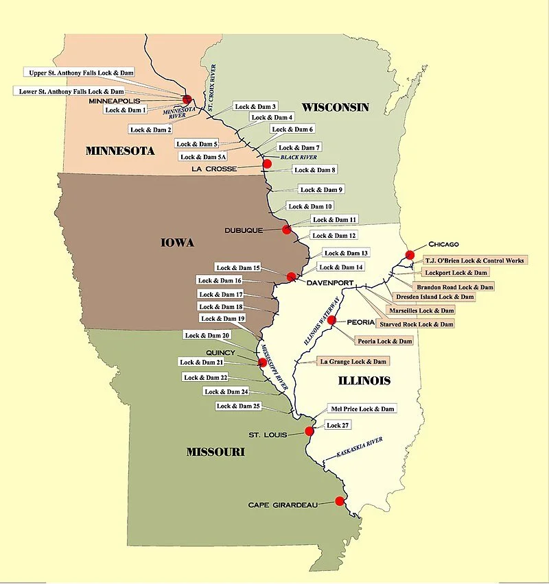
VI. Wild Rice Regime: Mississippi River Lock & Dam Quitclaim Deed Wild Rice Regime MRLDQDWRR
Wild Rice Saint Croix, Mississippi
The Mississippi River serves as a vital shipping lane, handling 47% of US inland waterborne commerce. It facilitates the movement of over 669 million tons of cargo annually, including agricultural products, petroleum, and other materials. This navigation system is worth approximately $400 billion annually and supports a substantial shipping industry. However, the aging lock and dam infrastructure on the Upper Mississippi can lead to delays and increased costs, and is vulnerable to disruptions caused by drought and system failures. In fact, it is estimated that the closure of a single lock on the Upper Mississippi could result in the loss of thousands of jobs and billions of dollars in economic activity in the corn and soybean industries alone.
Agriculture: The fertile floodplain of the Mississippi River is crucial for US agriculture. The basin produces 92% of the nation's agricultural exports, including 78% of the world's feed grains and soybeans, and most of the livestock and hogs produced nationally which could be upgraded where the fertilizer market is projected to reach $38b and can be decentralized into regional corridors that match the animal based fertilizer to the crop protection demand to reduce wasted transportation increase organic bio-based fertilizers technological advancements in fertilizer application in sustainable agriculture
Manufacturing: The manufacturing sector in the Upper Mississippi River (UMR) corridor generates over $345 billion annually and supports more than 1 million jobs, including a significant portion of manufacturing jobs.
The Dutch spice trade & French spice trade are strong in the Mississippi River as discovered botany in modern cooking from peppers to tomato to maize to squash to beans. Building an apple regime a Blueberry Pine regime as companions and building rebuilding Wild Rice regime that was already here upgraded with American USDA in healthy alternatives to high fructose corn syrup (which cause Diabetes as elaborated in Metabolic Topology of Human Physiology) https://www.profee.me/physician-services
The Wild and Scenic Rivers Act, signed in 1968 CE and a reflection of that increased environmental awareness, protects certain rivers with outstanding natural, cultural, and recreational values in a free-flowing condition for public benefit and enjoyment. The Saint Croix River was one of the first eight river systems in the nation to be protected under this law and the state barrier between Minnesota & Wisconsin. The quitclaim wild rice regime can help SEUSQUESTER excess nutrients in the rivers lakes and streams into food through wild rice, blueberry PIne, apple regime, maple or or honey regime, vine melon watermelon grape Vinescraper regime, and adding an upper canopy such as Tulip Poplar in a opposition Spice regime policy to monoculture whether corn or not sport fishing or not
I. Upper Saint Anthony Falls Lock and Dam Minneapolis, Minnesota ~854 44°58′54″N 93°15′31″W 799 feet Last lock upstream on river. Since June 9, 2015, the lock has remained closed to prevent the spread of invasive Asian Carp.[2] Located within the Mississippi National River and Recreation Area.
II. Lower Saint Anthony Falls Lock and Dam Minneapolis, Minnesota ~853 44°58′42″N 93°14′49″W 750 feet Owned/operated by U.S. Army Corps of Engineers, Mississippi Valley Division, St. Paul District Meeker Island Lock and Dam
(demolished) Minneapolis, Minnesota / St. Paul, Minnesota ~850 44°57′14″N 93°12′28″W NA Demolished. Originally known as Lock and Dam No. 2 Lock and Dam No. 1Minneapolis, Minnesota / St. Paul, Minnesota ~847.8 44°54′55″N 93°12′02″W 725 feetIII. Ford Plant Powerhouse on east side. Owned/operated by U.S. Army Corps of Engineers, Mississippi Valley Division, St. Paul District Lock and Dam No. 2Hastings, Minnesota ~815 44°45′35″N 92°52′07″W 687 feet Owned/operated by U.S. Army Corps of Engineers, Mississippi Valley Division, St. Paul District
III. RED WING
Lock and Dam No. 3Red Wing, Minnesota 796.9 44°36′36″N 92°36′37″W 675 feet Owned/operated by U.S. Army Corps of Engineers, Mississippi Valley Division, St. Paul District
IV. ALMA WI Lock and Dam No. 4Alma, Wisconsin ~753 44°19′32″N 91°55′13″W 667 feet The lock is on the Wisconsin side right next to a small cafe. Owned/operated by U.S. Army Corps of Engineers, Mississippi Valley Division, St. Paul District
V. WINONA MN
Lock and Dam No. 5Winona County, Minnesota ~738.1 44°09′40″N 91°48′39″W 660 feet Visitor parking next to the lock. Owned/operated by U.S. Army Corps of Engineers, Mississippi Valley Division, St. Paul District
VA. GOODVIEW MN
Lock and Dam No. 5AGoodview, Minnesota ~728.5 44°05′18″N 91°40′08″W 651 feet Owned/operated by U.S. Army Corps of Engineers, Mississippi Valley Division, St. Paul District
VI. TREMPEALEAU
Lock and Dam No. 6Trempealeau, Wisconsin ~714.1 43°59′59″N 91°26′18″W 646 feet Owned/operated by U.S. Army Corps of Engineers, Mississippi Valley Division, St. Paul District
VII. LA CRESCENT
Lock and Dam No. 7La Crescent, Minnesota ~702.5 43°52′01″N 91°18′26″W 639 feet Adjacent to I-90 Mississippi River Bridge. Visitor parking and information next to the lock. Owned/operated by U.S. Army Corps of Engineers, Mississippi Valley Division, St. Paul District
VIII. GENOA
Lock and Dam No. 8Genoa, Wisconsin ~679.2 43°34′12″N 91°13′54″W 631 feet Visitor parking right next to the lock. Owned/operated by U.S. Army Corps of Engineers, Mississippi Valley Division, St. Paul District
IX. HARPERS FERRY
Lock and Dam No. 9Harpers Ferry, Iowa ~647.9 43°12′46″N 91°06′15″W 620 feet Parking area next to lock on Wisconsin side. Owned/operated by U.S. Army Corps of Engineers, Mississippi Valley Division, St. Paul District
X. GUTTENBERG IA
Lock and Dam No. 10Guttenberg, Iowa ~615.0 42°47′06″N 91°05′42″W 611 feet Owned/operated by U.S. Army Corps of Engineers, Mississippi Valley Division, St. Paul District
XI. DUBUQUE IA
Lock and Dam No. 11Dubuque, Iowa ~583 42°32′25″N 90°38′39″W 603 feet Owned/operated by U.S. Army Corps of Engineers, Mississippi Valley Division, Rock Island District
XII.BELLEVUE IA
Lock and Dam No. 12Bellevue, Iowa ~556.7 42°15′41″N 90°25′12″W 592 feet Owned/operated by U.S. Army Corps of Engineers, Mississippi Valley Division, Rock Island District
XIII. FULTON IL
Lock and Dam No. 13Fulton, IL ~522.5 41°53′53″N 90°09′21″W 583 feet Owned/operated by U.S. Army Corps of Engineers, Mississippi Valley Division, Rock Island District
XIV. LECLAIRE IA
Lock and Dam No. 14LeClaire, Iowa ~493.2 41°34′24″N 90°23′56″W 572 feet Owned/operated by U.S. Army Corps of Engineers, Mississippi Valley Division, Rock Island District
XV. ROCK ISLAND IL
Lock and Dam No. 15Rock Island, Illinois ~482.8 41°31′07″N 90°34′08″W 561 feet Owned/operated by U.S. Army Corps of Engineers, Mississippi Valley Division, Rock Island District
XVI. MUSCATINE IA
Lock and Dam No. 16Muscatine, Iowa ~457.2 41°25′32″N 91°0′35″W 545 feet Owned/operated by U.S. Army Corps of Engineers, Mississippi Valley Division, Rock Island District
XVII. NEW BOSTON IL
Lock and Dam No. 17New Boston, Illinois ~437 41°11′27″N 91°03′37″W 536 feet Owned/operated by U.S. Army Corps of Engineers, Mississippi Valley Division, Rock Island District
XVIII. GLADSTONE IL
Lock and Dam No. 18Gladstone, Illinois ~410.5 40°52′54″N 91°01′27″W 528 feet Owned/operated by U.S. Army Corps of Engineers, Mississippi Valley Division, Rock Island District
XIX. KEOKUK IA
Lock and Dam No. 19Keokuk, Iowa ~364 40°23′41″N 91°22′29″W 518 feet Owned/operated by U.S. Army Corps of Engineers, Mississippi Valley Division, Rock Island District
XX. CANTON MO
Lock and Dam No. 20Canton, Missouri ~343 40°08′37″N 91°30′46″W 480 feet Owned/operated by U.S. Army Corps of Engineers, Mississippi Valley Division, Rock Island District
XXI. QUINCY IL
Lock and Dam No. 21Quincy, Illinois ~324.9 39°54′23″N 91°25′56″W 470 feet Owned/operated by U.S. Army Corps of Engineers, Mississippi Valley Division, Rock Island District
XXII. SAVERTON MO
Lock and Dam No. 22Saverton, Missouri ~301.2 39°38′18″N 91°14′49″W 460 feet Owned/operated by U.S. Army Corps of Engineers, Mississippi Valley Division, Rock Island District
XXIV. CLARKSVILLE MO
Lock and Dam No. 24Clarksville, Missouri ~273.4 39°22′36″N 90°54′30″W 449 feet Owned/operated by U.S. Army Corps of Engineers, Mississippi Valley Division, St. Louis District
XXV. WINFIELD MO
Lock and Dam No. 25Winfield, Missouri ~241.4 39°00′17″N 90°41′11″W 434 feet Owned/operated by U.S. Army Corps of Engineers, Mississippi Valley Division, St. Louis District
XXVI. ALTON IL
Lock and Dam No. 26 (historical)Alton, Illinois ~202.5 38°53′10″N 90°10′55″W 419 feet Demolished, replaced by Melvin Price Locks and Dam. Melvin Price Locks and Dam
aka Lock and Dam No. 26 East Alton, Illinois ~200.8 38°52′09″N 90°09′13″W Owned/operated by U.S. Army Corps of Engineers, Mississippi Valley Division, St. Louis DistrictXXVII GLASGOW VILLAGE MO
Chain of Rocks Dam
aka Dam No. 27 Glasgow Village, Missouri ~190.2 38°45′27″N 90°10′39″W 398 feet Owned/operated by U.S. Army Corps of Engineers, Mississippi Valley Division, St. Louis District Chain of Rocks Lock
aka Lock No. 27 Granite City, Illinois38°42′11″N 90°10′51″W Owned/operated by U.S. Army Corps of Engineers, Mississippi Valley Division, St. Louis DistrictFriends of R.D. Pike Building, Inc is a 501C3 non-profit organization working to restore and preserve the oldest state fish hatchery building in the State of Wisconsin. Mr. Robinson Derling Pike culured fish on these grounds through the mid 1990s. The state of Wisconsin purchased the property, equipment and 600 acres for $1 with the understanding that the grounds would be used in perpetuity to raise fish for the public which implied building the fish stock year over year PERMIAN. The State built the hatchery building in 1897 CE. Today, it is a national historic building and fish are still raised for Wisconsin inland lake within her walls