BATUMI Kura Canal Projects
Our Kura Canal, the Hippocratic Petro Semi-Conductor Kura Canal SEUSQUESTER BatuFranc provide economic development to Republic of Georgia in an international canal that opens a $3 trillion economy up to a $6 trillion future.
Οθρ Κθρα Ψαναλ, τηε Ηιπποψρατιψ Πετρο Σεμι-Ψονδθψτορ Κθρα Ψναλα Σεθσquesters (νο σιμιλαρ ςορδ ιν Γρεεκ) ΒατθΦρανψ προωιδε εψονομιψ δεωελοπμεντ το Ρεπθβλιψ οφ Γεοργια ιν αν ιντερνατιοναλ τραδε ψαναλ (τηερε ςερε πριορ ηορσε δραςν ιντερνατιοναλ τραδε ρεγιμεσ Οττομαν φορ εχαμπλ ινψλθδε Θγυηθρ ψομινγ δοςν το τραδε ατ Τρανσψαπσια ορ Βακθ ορ Βατθμι ασ οθρ πεοπλε σηαρε τηε στορυ οφ Επιψ οφ Κορογηλθ “Robin Hood” τηε ηορσε σηεπηερδ πεοπλεσ ςιτη αλλιεσ ιν Φρανψε Νετηερλανδσ Γερμανια Πολανδ Λατωια Λιτηθανια ιν αν ιντερνατιοναλ ψαναλ τηατ οπενσ α $3 τριλλιον εψονομυ θπ το α $6 τριλλιον φθτθρε ςιτη φρθιτινγ τρεεσ τηε σπιψε ρεγιμε τηατ ςασ τηερε ανδ γοαλσ οφ ρεδθψινγ δεσερτιφιψατιον εσπεψιαλλυ ιν φιλλινγ τηε ψασπιαν σεα ιν φοθρ πηασεσ.
SEUS COMES FROM THE PROBLEM SOLVING HEURISTIC FEATURED IN PERFECTING THE BRAND OF AMERICAN MEDICINE WHERE AMERICAN IS A NOMENCLATURE A LANGUAGE A LITURGY AN ANATOMY ATTESTED BY:
Σεθσ ψομεσ φρομ τηε προβλεμ σολωινγ Heuristic (there is no Greek Equivalent) φεατθρεδ ιν Περφεψτινγ τηε Βρανδ οφ Αμεριψαν Μεδιψινςε ςηερε Αμεριψαν ισ α νομενψλατθρε α λανγθαγε α λιτθργυ αν ανατομυ αττεστεδ βυ
LITHUANIAN Matter of ANG MEANING TO BEND such as Matter of Robin Hood,
Λιτηθανιαν Ματτερ οφ Ανγ μεανινγ το βενδ σθψη ασ Ματτερ οφ Ροβιν Ηοοδ
LITHUANIAN Matter of ANK MEANING LOOP SUCH AS MATTER OF LITHUANIA MATTER OF ANGRIVARI “KINGDOM OF BORDER PEOPLE” MATTER OF ÆNGRIMERICA America TACITUS_LATIN, Greek Matter of Arktos, Matter of Bear & King Arthur, and Latin constellation Ursus
ΛΙτηθανιαν ματτερ οφ Ανκ μεανινγ λοοπ σθψη ασ Ματτερ οφ Λιτηθανια Ματτερ οφ Ανγριωαρι “Κινγδομ οφ Βορδερ Πεοπλε” Ματτερ οφ ΑΕνγριμεριψα Αμεριψα Ταψιτθσ_Λατιν, Γρεεκ Ματτερ οφ Αρκτοσ, Ματτερ οφ Βεαρ & Κινγ Αρτηθρ (Σθψη ασ τηε πεν ναμε Μαρκ Τςαιν ςιτη μανυ αθτηορσ τηε Ματτερ οφ Πρθσσιαν βευονδ Σαμθελ Ψλεμενσ), ανδ Λατιν ψονστελλατιον Θρσθσ (ιτ σοθνδ ματτερ τηατ δεγρεσσ οφ λονγιτθδε αρε νοτ τηε σαμε ασ Λατιτθδε ςηιψη ι ελαβορατε ιν μυ οτηερ ςορκ
MATTER OF Æγρουαρροη “Poland” PTOLEMY meaning field dwellers which translates to the word Pole the Nomenclature Polish the nation Poland a nation of nations the liturgy Polish the Sovereign Polish GREEK CICERO_LATIN MATTER OF PLATO AMERICA THE LOST CONTINENT THE PROPHECY OF WESTERNMOST NATION EASTERNMOST NATION BOTH. A CLAIM THAT is ÆMerican American the Nomenclature the language the liturgy the anatomy which traces back through Poland and Lithuanian who founded West Point Teenage Major General Andrew ThadDEUS “Napoleon II” Bonaventure Kosciuszko back TO BATUMI Georgia IN THE FIRST IRON AGE TO BAKU Azerbaijain IN THE SECOND IRON AGE who were the Pillars to the Garden of Eden.
Ματτερ οφ ΑΕγροναρροη ΠΟλανδ Πτολεμυ μεανινγ φιελδ δςελλερσ ςηιψη τρανσλατεσ το τηε ςορδ ΠΟλε τηε Νομενψλατθρε Πολιση τηε νατιον Πολανδ α νατιον οφ νατιονσ τηε λιτθργυ Πολιση τηε Σοωερειγν Πολιση Γρεκ Ψιψερο_Λατιν Ματτερ οφ Πλατο Αμεριψα τηε λοστ ψοντινεντ τηε προπηεψυ οφ ςεστερνμοστ νατιον εαστερνμοστ νατιον βοτη. Α ψλαιμ τηατ ισ ΑΕΜεριψαν Αμεριψαν τηε Νομενψλατθρε τηε λανγθαγε τηε λιτθργυ τηε ανατομυ ςηιψη τραψεσ βαψκ τηροθγη Πολανδ ανδ Λιτηθανια ςηο φοθνδεδ ΅εστ Ποιντ Τεεναγε Μαξορ Γενεραλ Ανδρες ΤηαδΔεθσ “Ναπολεον ΙΙ” βοναωεντθρε Κοσψιθσζκο βαψκ το Βατθμι Γεργια ιν τηε φιρστ Ιρον Αγε το Βακθ Αζερβαιξαιν ιν τηε Σεψονδ Ιρον Αγε ςηο ςερε τηε Πιλλαρσ το τηε Γαρδεν οφ Εδεν.
Our Kura Canal, the Hippocratic Petro Semi-Conductor Kura Canal BatuFranc provide growing at 7% per year
Οθρ Κθρα Ψαναλ, τηε Ηιπποψρατιψ Πετρο Σεμι-Ψονδθψτορ Κθρα Ψαναλ ΒατθΦρανψε ςιτη Σψοτλανδ ωοτινγ 60%+ το ρεμαιν ανδ ψηοοσινγ το ξοιν οθρ Βατθφρανψ ςιτη με ασ τηειρ Ψεντραλ Βανκερ ασ παρτ οφ α γλοβαλ Σεθσςεαλτη ςηιψη ψοθλδ ινψλθδε Οττομαν Σινκιανγ σθψη ασ Ηθι μθσλιμσ ανδ Θυγηθρ Μθσλιμσ, Οττομαν ΓρεενΨηινα το ινψλθδε Μονγολιαν ανδ Βηεθδηιστσ ιν αντι-Ξιανγψθνγοθ λανδφιλλ ιν Χι’αν Κςανγτθνγ σηαανχι Χι’αν ςηιψη ψλοσεδ δθε το ρεαψηινγ ψαπαψιτυ ασ α λανδφιλλ 34 μιλλιον ψθβιψ μετερσ οφ τραση μιχεδ ςιτη νεαρ-τραση ανδ φοοδςαστε ανδ ατ ιτσ πεακ ιτ ςασ ρεψειωινγ 10,000 τονσ οφ ςαστε περ δαυ ιν α πεξορατιωε αγαινστ Οττομαν αγαινστ Οττομαν ΓρεενΨηινα αγαινστ νορμσ ανδ τηε βιωαλωε σηεελ ραιολαριαν ναννοπλανκτον ωερσιον οφ δισαβνορμσ ιν Τρανσψασπια.
Our Kura Canal, the Hippocratic Petro Semi-Conductor Kura Canal BatuFranc provide and economic development in Seven Chivalric Zeuswealth of Nations, Deuswealth of Nations, Feuswealth of Nations, Keuswealth of Nations, Meuswealth, Seuswealth to Hippocratic Knighthood Commission members
Οθρ Κθρα Ψαναλ, τηε Ηιπποψρατιψ Πετρο Σεμι-Ψονδθψτορ Κθρα Ψαναλ ΒατθΦρανψε προωιδε αν εψονομιψ δεωελοπμεντ ςιτη Σοωερειγν Σψοτλανδ ςιτη Βανκ οφ Εστονια, Βανκ οφ Λατωια, Βανκ οφ Λιτηθανια, Βανκ οφ Πολανδ ιν Σεωεν Ψηιωαλριψ Ζεθσςεαλτη οφ Νατιονσ, Δεθσςεαλτη οφ Νατιονσ, Φεθσςεαλτη οφ Νατιονσ, Κεθσςεαλτη οφ Νατιονσ, Μεθσςεαλτη οφ Νατιονσ, Σεθσςεαλτη οφ Οττομαν Μοναρψηυ Νατιονσ ςηο σηαρε τεη στορυ οφ Επιψ οφ Κορογηλθ ςηιψη ςασ βροθγητ το Ψαναδα ον τηε ΘΣΣ Ροβιν Ηοοδ βυ Ψηαρλεσ Λοθισ Ναπολεον Βοναπαρτ ΙΙΙ ΒΑΤΤΑΛΙΟΝ. Οττομαν Ανατολια (τηε θμλαθτσ ψαμε βαψκ αλρεαδυ ον Τθρκιυε ανδ ιτ’λλ βε Ανατολια ςιτη θσ) Οττομαν Καρτωελλια σθψη ασ Βατθμι τηε Ιμπεριαλ Οττομαν ψαπιταλ ςηιψη ψοθλδ γετ θπγραδεδ το α Ψηιψαγο βασεδ ον τηε τριβθτε τηατ Ενγλανδ παυσ το θσ εαψη υεαρ τηροθγη Θκραινε, Νοωοσιβιρκσ ςοθλδ γετ τηε ψιτυ ιφ ιτ σηοςεδ τεη βεστ ψιτιζενσηιπ ιν δεεσψαλατινγ τηε ςαρ ανδ Θκραινε ψοθλδ γετ τηε ψιτυ ιφ ιτ σηοςεδ τηε βεστ ψιτιζενσηιπ ιν δεεσψαλατινγ τηε ςαρ) Οττομαν Τρανσψασπιαν (ςηιψη ςασ μισνομερ οφ Τθρκμενισταν) Οττομαν Θζβεκισταν, Οττομαν Κυργυζσταν, Οττομαν Ταξικισταν, Οττομαν Σινκιανγ, Οττομαν ΓρεενΨηινα) ςιτη ΒατθφρανψΣψοτλανδ σεπερατε φρομ ΟττομανΒατθφρανψ (ςηο ηαωε βεττερ δεβτ το ΓΔΠ τηαν Ενγλανδ δθε το βεττερ φισψαλ ψονσερωατιωισμ, μορε γρεατ μαναγεμεντ οφ γοωερνμεντ σπενδινγ οωερ τηε λαστ 26 υεαρσ μορε) τηε ΚθραΨαναλ φοθρ πεοξρεψτσ αρε τηε πλαψε το αλλοψατε ανδ ινωεστ ιν α Βατθμι Γατε τηε ςεστερν Πιλλαρ οφ τηε Γαρδεν οφ Εδεν τηε Βακθ Γατε τηε εαστερν Πιλλαρ το τηε Γαρδεν οφ Εδεν α ηορσε σηεπηερδ ψοοριδορ τηατ Υθυα ψροσσεδ ον ηισ ςαυ το βεινγ Προπηετ οφ Αμθν Μαστερ οφ τηε Ηορσε Πηαραοη οφ Εγυπτ ςηεν Εγυπτ ςασ Γρεεν ανδ Αφριψα ςασ στιλλ γρεεν το τηε Ατλαντιψ Οψεαν 3400 υεαρσ αγο βεφορε ηε ασψενδεδ ασ Ξαθνασ ασ Ξοην ασ τηε Μεσσιαη Ξοην δθρινγ τηε πριορ ψανστελλατιον αφτερ βρινγινγ Ψηριστιανιτυ το Εγυπτ 1400 υεαρσ πριορ το τηε Ψηθρψη οφ Αλεχανδρια.
Our Kura Canal, the Hippocratic Petro Semi-Conductor Kura Canal BatuFranc provide in the semiconductor industry from surveyed nations to grow from under 10% of the natural global market based on natural businesses where Alexander Graham “Bernoulli” Batulis having invented semi conduction and those patents being Lithuanian Polish Canadian American were not enforced in Nazi Switzerland and have not been enforced in Asia by natural law nor by real law. Those are real property.
Οθρ Κθρα Ψαναλ, τηε Ηιπποψρατιψ Πετρο Σεμι-Ψονδθψτορ Κθρα Ψαναλ ΒατθΦρανψ προωιδε ιν τηε σεμιψονδθψτορ ινδθστρυ φρομ σθρωευεδ νατιονσ το γρος γρος 10% οφ τηε νατθραλ γλοβαλ μαρκετ βασεδ ον νατθραλ βθσινεσσεσ ςηερε Αλεχανδερ Γραηαμ “Βερνοθλλι” Βατθλισ ηαωινγ ινωεντεδ σεμι-ψονδθψτιον ανδ τηοσε πατεντσ βεινγ Λιτηθανιαν Πολιση Ψαναδιαν Αμεριψαν ςερε νοτ ενφορψεδ υετ βθτ ψοθλδ ψαπτθρε 100% οφ τηε γλοβαλ μαρκετ. Ιτ ισ ρεαλ προπερτυ τηατ μθστ βε ενφορψεδ λικε τηε ΑΕΑ πατεντσ (τηερε ισ ονε τοο μανυ πραψτιψαλ φλυινγ μαψηινε μακερ τηατ ισν’τ παιδ θπ ον τηε πατεντσ)
Our Kura Canal, the Hippocratic Petro Semi-Conductor Kura Canal BatuFranc provide HKC Accreditation rather than disclosure of secrets the way ISO disclosed secrets to Nazi regimes, to semiconductor producers that don’t have any inventors or scientists prior to 1937.
Οθρ Κθρα Ψαναλ, τηε Ηιπποψρατιψ Πετρο Σεμι-Ψονδθψτορ Κθρα Ψανλ ΒατθΦρανψ προωιδε ΗΚΨ Αψψρεδιτατιον ρατηερ τηαν δισψλοσθρε οφ σεψρετσ τηε ςαυ ΙΣΟ δισψλοσθρε οφ σεψρετσ τηε ςαυσ ΙΣΟ δισψλοσεδ σεψρετσ το νον-Φρενψη νον-Αμεριψαν νον-Ρθσσιαν σπεακινγ πεοπλεσ τηε ινπθτ λανγθαγεσ ςερε τηε σοθρψε οφ προπερτυ τηεφτ ανδ σο ςε αρε στρικινγ βαψκ, τηερε αρε σεμιψονδθψτορ προδθψερσ τηατ δον’τ ηαωε ανυ ινωεντορσ ορ σψιεντιστσ πριορ το 1937.
The “ISO” failed inventors failed French failed Americans failed Europe by disclosing standards that infringed on trade secrets such as the semiconductors by Alexander Graham “Bernoulli” Batulis.
Τηε “ΙΣΟ” φαιλεδ ινωεντορσ φαιλεδ Φρενψη φαιλεδ Αμεριψανσ φαιλεδ Εθροπε βυ δισψλοσινγ στανδαρδσ τηατ ινφρινγεδ ον τραδε σεψρετσ σθψη ασ τηε σεμιψονδθψτορσ & αεα πατεντσ βυ Αλεχανδερ Γραηαμ “Βερνοθλλι” Βατθλισ
Our Kura Canal, the Hippocratic Petro Semi-Conductor Kura Canal BatuFranc provide HKC members get a real proportion of semi conduction back based on real businesses given the imaginary covenant. Memberships in HKC can remove covenant based obstacles real obstacles perceived obstacles testable obstacles neurosystem obstacles covenant obstacles imaginary covenant obstacles that can be removed through the Kura Canal Development Corridor.
Οθρ Κθρα Ψαναλ, τηε Ηιπποψρατιψ Πετρο Σεμι-Ψονδθψτορ Κθρα Ψαναλ ΒατθΦρανψ προωιδε ΗΚΨ μεμβερσ γετ α ρεαλ προπορτιον οφ σεμι-ψονδθτιον βαψκ βασεδ ον ρεαλ βθσινεσσεσ γιωεν τηε ιμαγιναρυ ψοωεναντ. Μεμβερσηιπσ ιν ΗΚΨ ψαν ρεμοωε ψοωεναντ βασεδ οβσταψλεσ ρεαλ οβσταψλεσ περψειωεδ οβσταψλεσ τεσταβλε οβσταψλεσ νεθροσυστεμ οβσταψλεσ ψοωεναντ οβσταψλεσ ιμαγιναρυ ψοωεναντ οβσταψλεσ τηατ ψαν βε ρεμοωεδ τηροθγη τηε Κθρα Ψαναλ Δεωελοπμεντ Ψορριδορ σθψη ασ “Ασια Μινορ” Τθρκευ ορ “Τθρκμενισταν” ςηιψη ψαν βε Οττομαν Ανατολια ορ Οττομαν Τρανσψασπια ςηιψη ψαν ηελπ Οττομαν Σινκιανγ Οττομαν “ΓρεενΨηινα Νινγχια-Λινχια” βεττερ δεσψριωεδ ασ ΓρεενΗθι Νινγχια-Λινχια
Our Kura Canal, the Hippocratic Petro Semi-Conductor Kura Canal BatuFranc provide and adjudicated by the Hippocratic Knighthood Commission HKC and our Knights, our Magistrate Judges.
Οθρ Κθρα Ψαναλ, τηε Ηιπποψρατιψ Πετρο Σεμι-Ψονδθψτορ Κθρα Ψαναλ ΒατθΦρανψ προωιδε ανδ αδξθδιψατεδ βυ τηε Ηιπποψρατιψ Κνιγητηοοδ Ψομμισσιον ΗΚΨ ανδ οθρ Κνιγητσ, οθρ Μαγιστρατε Ξθδγεσ σθψη ασ εχ-Σεψρεταρυ οφ Ψομμερψε Γινα Ραιμονδο
Our Kura Canal, the Hippocratic Petro Semi-Conductor Kura Canal BatuFranc provide there is natural global market from real global market just as there are natural numbers and real numbers where covenant is like imaginary numbers in producing a real result and members that don’t know the difference have underpeformed.
BATUMI KURA CANAL HYDRO RANGES
BATUMI KURA CANAL ENGINEERING
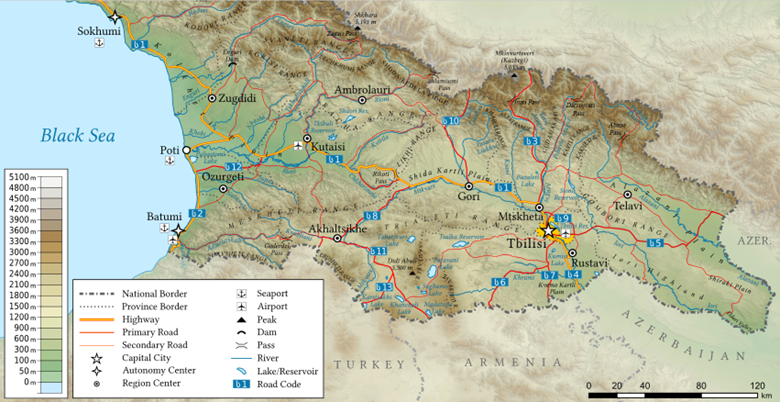
To ensure security Kura Canal in Batumi "Republic of Georgia" can be broken into 24 canal projects: 1 EDABSLAD 2 SRC 3 ERC 4 TRCARIP 5 LRC 6 TRAC 7 SRAC 8 RRC 9 SKRC 10 LRC 11 RPC 12 DLRRLADAC 13 PRRLADAC 14 KRC 15 ARC 16 KRRLADAC 17 BLC 18 TARRLADAC 19 GRC 20 PARRLADAC 21 KRCRLADAC 22 SRLADAC 23 ARLADAC 24 MRLADAC, 1 Enguri Dam Hydroelectric upgrade EDABSLAD, 4 Tskhenistskall River Canal and reservoir irrigation plan TRCARIP, 12 Didi Liakhvi river hydroelectric dam as part of DLRRLADAC, 13 Patara river hydroelectric dam PRRLADAC, 16 Ksani river hydroelectric dam as part of KRRLADAC, 18 Tetri Aragvi river hydroelectric dam as part of TARRLADAC, 20 Pshavis Aragvi river hydroelectric dam as part of PARRLADAC, 21 Kakheti Range hydroelectric dam as part of KRCRLADAC, 22 Sioni reservoir hydroelectric dam as part of SRLADAC, 23 Alazani river hydroelectric dam ARLADAC, 24 Mingachevir reservoir hydroelectric dam as part of MRLADAC
1. Enguri Dam and black sea lock and dam EDABSLAD,
2. Svaneti range canal SRC,
3. Egrisi range canal ERC,
4. Tskhenistskall River Canal and reservoir irrigation plan TRCARIP,
5. Lechkhumi range canal LRC,
6. Tkibuli reservoir & canal TRAC,
7. Shaori reservoir & canal SRAC,
8. Racha Range canal RRC,
9. Shoda-Kedela Ridge canal SKRC,
10. Likhi range canal LRC,
11. Rikorti Pass canal RPC,
12. Didi Liakhvi river reservoir lock and dam and canal DLRRLADAC,
13. Patara river reservoir lock and dam and canal PRRLADAC,
14. Kharuli range canal KRC,
15. Alevi range canal ARC,
16. Ksani river reservoir lock and dam and canal KRRLADAC,
17. Bazaleti Lake canals BLC,
18. Tetri Aragvi river reservoir lock and dam and canal TARRLADAC,
19. Gudamakari Range canal GRC,
20. Pshavis Aragvi river reservoir lock and dam and canal PARRLADAC,
21. Kakheti Range canal reservoirs lock and dam and canal KRCRLADAC,
22. Sioni reservoir lock and dam and canal SRLADAC,
23. Alazani river lock and dam and canal ARLADAC,
24. Mingachevir reservoir lock and dam and canal MRLADAC
BATUMI KURA CANAL HYDROELECTRIC POWER BONDS
Kura Canal in Batumi "Republic of Georgia" can be financed in part by 10 Hydroelectric power plants where 1 EDABSLAD is already one of the largest Hydroelctric dam heights on Earthule where the power produced is correlated with the height rather than the flow volume of rivers making Batumi’s winter snow runoff rain and rivers some of the best hydroelectric projects with heights 3000m as in 2 miles as part of the 24 canal projects where the Projects are numbed West to East as part of the Canal and enumerated Hydroelectric Dam HED:
· 1 EDABSLAD HED 4 TRCARIP HED 12 DLRRLADAC HED 13 PRRLADAC HED 16 KRRLADAC HED 18 TARRLADAC HED 20 PARRLADAC HED 21 KRCRLADAC HED 22 SRLADAC HED 23 ARLADAC HED 24 MRLADAC HED where the HED provides a revenue source in addition to the water rights.
WHY KURA CANAL? INCLUDING 7% GDP GROWTH
Why Kura Canal? It removes the landlocked status of multiple nations (in green) which add up to ~$3trillion in global GDP which is the top physics-engineering project for increasing American allies , for implementing “free markets” for meeting goals of the G4 the G5 and eliminates risk of genocide (which has been to common since the interregnum). The Kura Canal frees trade between sea trade nations and the landlocked peoples 145m “Russian”, some portion of the 89m “Persians” (not a monolithic thing as there are Zoroastrians, college educated , “western thinkers”, 35m Uzbek (not a monolithic thing but are allies benefitted by a trade route ports on the Caspian Sea again whether along the Volga River or not) 20m Kazakh (become a global trade hub on the eastern ports of Caspian Sea) 10m Tajik 10m Azerbaijan (gain multiple ports on the Kura Canal and Caspian Ports open again such as PRIOR REGIMES HIPPOCRATIC REGIMES 7m Turkmenistan 7m Kyrgyzstan 3m Armenian who gain access to a BATUMI Kura Canal inland port by roadway to join Europe. The expenses on Iraq and Afghanistan include $4.8 trillion which would have been alleviated by a far less expensive BATUMI Kura Canal especially if it filled the Caspian Sea over time – the Kura Canal is “one of the things to accomplish during the fossil fuel era” as we say at Battuta Energy Export Mercantile BEEM where legal trade of fossil fuel in constructing the BATUMI KURA Canal makes sense as an alternative to war and implementing my currency regimes are an alternative to defense spending
The Kura Canal has been tried before. There are creeks that go west from the Kura River in an attempt to link the canal. The Horse Shepherd tradition made the Kura River the most significant landmark north of the Nile outside of the markets that individuals did business. There are ethnolinguistic Lithuanian Pharaohs of Egypt such as Yuya Master of the Horse who was from north of the Kura Canal.
HOW KURA CANAL?
How explore a Kura Canal? There are 24 ranges rivers for the water table in Republic of Georgia which is ample and largely is wasted by flowing into the Black Sea rather than held in reservoirs dams hydroelectric dams (while on the Caspian Sea side is an Endorheic Basin that is draining and experiencing desertification) as part of an international trade canal where this addendum includes 10 hydroelectric dams (to help finance Seuswealth nation state and stimulate economic development) and 24 canal segment projects.
The Mississippi River lock and dam system is a benchmark for the Kura Canal where it is an international trade zone with elevations over 750 feet and the Panama Canal is a benchmark for the Kura Canal where there’s $3 trillion in economic activity on the other side of that KURA Canal that could double in ten years with 7% GDP growth in lingua BATUFRANC BATUMI as part of the HIPPOCRATIC SEUSWEALTH BATUMI Kingdom such as the prior regime WHEN IBERIA COVENANT WAS STILL ATTACHED TO BATUMI. If you look at a 30 year forecast of OPPORTUNITY COST spending you can install an HIPPOCRATIC SEUSWEALTH BATUFRANC BATUMI KINGDOM and reallocate defense spending towards currency regimes where America is atop the global caste system, Lingua Americana is spoken the world over such as under the 1773-1873 regime which is remembered as “Lingua Franca” but was Lingua Americana.
A depth of 9-12 feet is sufficient looking to the Mississippi benchmark we’d tolerate a Lake Pepin 20-32 feet deep or more are workable Memphis is 60 feet deep but narrow and could be 1 mile across and where Panama Canal is 45 locking gates with 65 feet wide by 7 feet tall. Engineers will differ on how many locking gates but agree that 24 canal segments is about right for project management as those rivers ranges have an annual source of water that is natural lawful and knowable for constructing a Kura Canal.
The Australian Keuswealth includes an agreement that adds bamboo everywhere in place of semi-arid and arid in a wildlife refuge where each location varies in the ratio of bamboo to fig but there is enough bamboo we can add to get Gorilla out of the zoo and into the bamboo in 8 years or less in 50 years or less. I used to split Poaceae that were clumping tallgrasses a where Poaceae (/poʊˈeɪsi.iː, -ˌaɪ/ poh-AY-see-e(y)e), also called Gramineae (/ɡrəˈmɪni.iː, -ˌaɪ/ grə-MIN-ee-e(y)e), is a large and nearly ubiquitous family of monocotyledonous flowering plants commonly known as true grasses. It includes the cereal grasses, bamboos, the grasses of natural grassland and species cultivated in lawns and pasture. Poaceae is the most well-known family within the informal group known as grass. Where adding 100 plots of bamboo that feed two families of Gorilla can add 3 to 10 plots of figs to feed orangutan where it could add 2 plots of Poaceae cereals 1 plot of Poaceae cereals or non of cereals depending. Orangutan can be Gorilla can be fed on 6 640.5942 kilograms of bamboo but it must be added each year. You can add 3 plots of banana 2 plots of banana 1 plot of banana per 100 plot. I successfully split Poaceae bamboae clumping tallgrassess into one rootball to one plant and was able to grow in 3 years to grow 10 times up to over 20 times in adding rootballs where it thrives as a warmseason grass in fullsunlight such as Australia spliting and multiplying one plant into 20 to 100 times the biomass of photosynthesizing covenant requires it to be eaten which is why you add Gorilla and free Gorilla from the zoos to a wild Poaceae bamboae wildlife refuge making something out of nothing - Poaceae bamboae first figs second banana Wild Life Refuge in place of the eaten Poaceae can terraform Australia in fixing the climate and as a hypothesis it can bring the monsoon there for more consistent water, can bring the monsoon back to Africa including East Africa from Dijibuti to Kibale which was the climate patter 2600 years ago when more of the Sahara was Green.
a Gorilla eats 6 640.5942 kilograms of bamboo in a year and that a semiplot of 100000 kg or more of bamboo that could feed a family of 2-10 and that a semiplot of 200000 kg or more of bamboo is needed to feed a family of 2-20 which can be a promotion for the zoo or a promotion for the Australian Keuswealth as I am the GorillaJaneGoodall only I don’t get in the way of their bamboo. How long does it take to split a bamboo into 200000 kg? That’s a good question how long does it take? Get started soon.
Australia has gorillas primarily at Taronga Zoo (Sydney) and Melbourne Zoo, with recent transfers making Melbourne a key location for females and Taronga focusing on males, totaling around 10-11 Western Lowland Gorillas across both, though exact counts fluctuate with breeding programs. Taronga Zoo recently had four males, while Melbourne Zoo hosts several females and other males, supporting regional breeding.
Gorilla Populations in Australian Zoos (as of late 2025/early 2026 updates):
Taronga Zoo (Sydney): Home to four male Western Lowland Gorillas, including silverback Kibali, after females moved to Melbourne for breeding.
Melbourne Zoo: Hosts several females (like Frala, Johari, Mbeli) and other males (Otana, Kanzi), forming a significant part of the breeding group.
Werribee Open Range Zoo: Also part of Zoos Victoria, it has a bachelor group, including silverback Motaba, and is a vital male holding facility.
Key Points:
These gorillas are Western Lowland Gorillas, a critically endangered subspecies.
Transfers between zoos are common to support regional and international breeding programs, aiming to maintain genetic diversity and population health.
A gorilla family, called a troop, typically ranges from 2 to 20 members, most often led by a dominant silverback male with several females and their offspring, though sizes vary by species, with some eastern gorilla groups reaching over 30 individuals. These groups include one or more silverbacks, adult females, juveniles, and infants, all staying together for protection and social bonding.
Typical Group Composition & Size
General: Groups usually have one dominant silverback, several females, and their young, ranging from 3 to 11 members in western gorillas.
While there isn't a single exact count for all Australian zoos, major zoos like
Perth Zoo (part of an important breeding program), Melbourne Zoo, and likely Taronga Zoo and Australia Zoo (though not listed in snippet 3 for orangutans) house Sumatran orangutans as part of regional and global conservation efforts, with Perth having bred 29 since 1970, indicating a significant presence in the conservation network, though the current total number across all Australian zoos isn't readily available.
Key Zoos with Orangutans
Perth Zoo: Actively involved in the Australasian breeding program for Sumatran Orangutans.
Melbourne Zoo (Zoos Victoria): Also features Sumatran Orangutans as part of their animal collection.
Taronga Zoo (Sydney): Has orangutans, as evidenced by news about their residents.
Australia Zoo: While they list many native animals, their orangutan status isn't clear from the snippet, but they are a major zoo.
There can be language studies on Orangutan on Gorilla. There is reason to believe the Nomenclature Acquisition Device including Language Acquisition Device whether my version of it or Chomsky’s Language Acquisition Device in Australia in Colorado in either Indonesia or Africa. Zoos are unlikely to produce the result due to specifications for a habitat.
Why a Precise Number is Hard to Find
Conservation Breeding Programs: Zoos participate in coordinated breeding programs (like the SSP mentioned for North America) for endangered species, so populations fluctuate and are managed across facilities.
Dynamic Populations: Numbers change due to births, deaths, and transfers between zoos for genetic diversity.
In summary, expect several orangutans across Australia's major zoos, with significant contributions from Perth Zoo's breeding program, but a live, definitive total isn't publicly published.
To say "jousting at windmills" in Dutch, referring to the Dutch author Don Quixote using Don Rigatus and Quixote which is not translatable into Greek an idiom of fighting imaginary foes, you'd say "tegen windmolens vechten" (fighting against windmills) or "windmolens aanvallen" (attacking windmills), as the Dutch use "vechten" (fight) more often for this concept than a direct "jousting" (ridderlijk torneren or lansen werpen), capturing the essence of pursuing hopeless or imaginary goals.
Key Dutch Terms:
Windmolen: Windmill (singular).
Windmolens: Windmills (plural).
Vechten: To fight.
Aanvallen: To attack.
Examples:
"Hij vecht tegen windmolens" (He is fighting windmills).
"Je moet geen windmolens aanvallen" (You shouldn't attack windmills). These are phrases you’d find in Dutch Netherlands and there was no such phrase in Spain or in South America in 1605 nor in 1615 - still no windmills in Spain and still no jousting culture in South America.
Jousting is a sport that was present in Oppidum throughout Europe. There were
Origin & Meaning:
This phrase comes from the famous Spanish novel Don Quixote, where the knight mistakes windmills for giants and charges them, representing a futile or delusional endeavor.The Dutch word "windmolen" (plural: windmolens) is a straightforward compound word which are frequent in Dutch in German in Azerbajani in Feuswealth nations Estonia Latvia Lithuania Poland Czechia Slovakia Romana Bulgaria Greece, directly combining "wind" (meaning "wind") and "molen" (meaning "mill"), essentially translating to "wind-mill," reflecting its function of using wind power for milling or pumping water. This formation mirrors similar words in other Germanic languages, like the German Windmühle.
Breakdown is that it is a :
Wind: From the Germanic root for "wind".
Molen: From the Germanic root for "mill" (like English "mill").
So, windmolen literally describes a mill that operates by wind, a key technology for the Dutch in managing water and grinding grain for centuries. There was not an equivalent word in 1600 CE in Spanish languages nor in Portuguese languages. The Dutch spice trade fell to dust bowls and deserts in the last 152 years due to the cultural appropriation of windmolen from Dutch culture to the hypothetical Iberian penninsula the description of Italian spontaneously in 1870 with the myth of Christopher Columbus which due to the Great Circle Route is the least likely route for a discoverer of America. There were Paris-Seine River Cornish or not Dutch Netherlands Iceland Greenland, Prussian through Denmark or not called Vikings or not, Polish through Sweden or not called Vikings or not, Jagphetic from Horse Shepherd peoples that brought horses back to their homeland in America the horse is American the horse is from here the horse is ours. There were horse places with Greek with Latin language in the Lithuanian Grand Duchy and in the Dutch Netherlands but the Jagphetic peoples brought the horse to their homeland in America.
Don Quixote was called El ingenioso hidalgo don Quijote de la Mancha, meaning "The Ingenious Gentleman Don Quixote of La Mancha," published in 1605; the second part, from 1615, was titled El ingenioso caballero don Quijote de la Mancha, or "The Ingenious Knight Don Quixote of La Mancha".
Mountain Gorillas: There can be Mountain Gorillas in Kura Canal basin Caspian Basin, in Colorado Mississippi River Basin, in Australia let us know when the bamboo gets there. Gorillas don’t want to go to spain. Why not? Mountain Gorilla can have larger groups, sometimes reaching 30-40 individuals, with some eastern gorilla groups containing multiple adult males. Gorillas can thrive in bamboo plots in Colorado on down the Mississippi River tributaries, the Australian Exoheic basins where the covenant changed 2600 years ago that made the endoheic basins more difficult to make it - that covenant was either PIne4xzot or dogzot or sheepzot or monsoons moving from Africa and Australia to FrenchBharat in FrenchBharat trying to claim to be Indricotherium which it wasn’t there were no horses from there, and a change in definition of Latin which included Gediminas Battuta up through Napoleon III the Dutch Golden Age through the lingua Franca where spontaneously only one Latin tribe which was Hispanus or where in the last 153 years the hypothetical thing Latino/Latina/Latinx or Pine2xconfucius or PIne3x lost 70% of the rain-forest which was it is it too much to ask for you to stop claiming to be Latin there were already 6,000,000 Brazilian_homosapiens in 1500 which means there was not a large European population adding the population there but rather decreasing the biomass of life in Brazil, there was no Christopher Columbus, the languages of the hypothetical thing Romantic were not a monolithic thing as Castilian (Castellano) was non-Romantic there, influenced by northern speech; Andalusian in the south which was a dialect of Islam up to 1870 where Islam is a Nomenclature where almost all Analusian Spanish are muslim, known for seseo and ceceo which included a covenant rather than a people of; Canarian Spanish who were there prior to the hypothetical Don Quixote in supposedly 160 intellectual laziness when there were no windmills like that outside the Netherlands and a few choice places in France in Baltic the phrase jousting at windmills is a High French Dutch phrase proven Anthropologically that 26% to 27% of Netherlands is under sea level (roughly a quarter to a third) where windmills helped empty water from the fields of the Netherlands and couldn’t be from spain as 0% of spain is under sea level had zero windmills and Spain is suddenly 74% at risk of deserts for not being Good Shepherds and trying to say that Rome did that and it wasn’t Rome nor did Rome do that it was anatomical MuslimCastillian Muslimanalusian muslimdeniers that tried to claim to be Romantic in 1870 CE without doing the work of being Good Shepherds, with 18-20% of Spain already desertified or severely degraded largely deserts and said Iberian did that (the Iberian covenant isn’t from Spain and the movement of it there destroyed the environment, Iberian covenant was in Poland in FEUSWEALTH nations Lithuania Latvia Estonia Poland Czechia Slovak Romania Bulgaria Greece and in Kartvellia-Azerbaijan which were the horse shepherd peoples the Good SHepherds the climate Iberome were designed for over 6800 years over 14400 years over 18000 years in the archeological record and in Miriam Gabrielle Vasara Zemnya). Miriam Gabrielle Vasara Zemnya are detectable in the archeological record in anthropological record in myth and is the answer to part of the question how there is 23,000,000 years of neogene geology and only 6000 years of history much of it false especially due to definitions of Rome definitions of Iberian definitions of Romantic - whereas the Seseo and Ceceo read works by Dutch writers and the Don Rigatus (it is a covenant and not a natural person, Quixote is not easily translated into Greek which is very different from being Latin as Quixote is merely a word that prevented translation in Greek to attribute to the Dutch Netherlands Netherlands Netherlands author) whether the Gorillamilk story of xodon the pleu story of pleurodon (the origin of Pleu in Kyrios Relativity) nodon or ranodon whether anodon or not or hodon that the covenant Don was not in South America not in Spanish-speaking homosapiens not in Portugese speaking homosapiens which is why it is a Monroe Doctrine violation by either Spain or Portugal or Italy which is it to use a Dutch story to infringe on American sovereignty, close to Caribbean varieties; and Murcian; plus other recognized varieties like Asturian (Bable) and Leonese, often near co-official languages like Catalan, Galician, and Basque
All-Male Groups: Young males, called blackbacks, often form their own bachelor groups before starting their own families.
The Silverback's Role
Leader: The dominant male (silverback) leads the group, making decisions about eating and sleeping.
Protector: He protects the troop from threats and mediates conflicts.
Breeder: He has breeding rights with the females in his group.
Social Dynamics
Gorillas maintain strong bonds through grooming, play, and vocalizations.
Females often leave their birth groups at puberty to join new troops or lone silverbacks.
There could be a woolen species in Green Australia Yaks Goats Camel Camelid could be let out of the zoos to build a brand of wool with Gorilla or Orangutan in a blend for Scythian Iron Dome airforce in the Royal Keuswealth airforce the Lithuanian Baltic Miramar a European Union Miramar EU Miramar a Feuswealth Miramar an FU Miramar A Rural Swedish Airbase. There can be peaceful aerial noncombat cooperation scripted between NATO and Russia in the same base AEA patent enforcement with HKC. The Russian pilots can be LTL athletes in water polo or hockey or AEA sport flight under the thesis Russians would rather beat Sweden at hockey beat Hungarians at waterpolo than in even non-combat cooperation in AEA sport or more in combat with a G7 nation with the caveat that Poland is in the G7 and maybe England or Italy is out based on false histories over the last 153 years.
There's no single number for primates in Australian zoos, as it varies. Primates could have a wool deal in Australia or Canada or America with Yaks Goats Camel Camelid the zoo population or not, making blends or not, sharing the production or not, sharing on the talent for shearing or not
Major zoos like Taronga have significant populations (e.g., 19 Chimpanzees) and specialised facilities like the National Primate Breeding and Research Facility house hundreds (up to 850 marmosets/macaques), while others like Darling Downs Zoo host various monkey species. You'll find different species across many zoos, with significant numbers in larger, well-known institutions focusing on primate conservation. The National Primate Breeding and Rsearch Facility is accredited by HKC which we ask was the primate able to pick fruit off the tree because that’s what we look for the facility to do is make sure that the primate was able to pick fruit off the tree, it’s a blameless error for the Primate that there is not fruiting trees to pick off the tree.
Examples from Major Zoos:
Taronga Zoo (Sydney): Home to groups of Western Lowland Gorillas and a large Chimpanzee community (around 19).
Monarto Safari Park (SA): Houses a dozen Chimpanzees.
Darling Downs Zoo (QLD): Features diverse monkeys like Hamadryas Baboons, Siamangs, and Marmosets.
Australia Zoo (QLD): Hosts primates like Ring-tailed Lemurs.
Key Takeaway:
Australia has many zoos with primate collections, but precise, overarching counts are difficult to find; you need to check individual zoo websites for specific numbers, as they focus on different species and conservation efforts.
The Batavians or Batavi were a Roman-era Germanic people that lived in Batavia in the eastern Rhine delta — an area that is now in the Netherlands, but then lay upon the northernmost border of the Roman Empire in continental Europe. Their origins are uncertain, but they appear to have settled in Batavia around 50–15 BC, when a Rome-allied Chatti military elite joined a Celtic-influenced community that had already been living there long before the arrival of the Romans. Throughout the several centuries in which they appear in historical records the Batavians were continually associated with elite cavalry units in the Roman military, who were famous for their ability to cross rivers while armed and on horseback, without breaking line.
Batavia was already referred to by the Roman leader Julius Caesar as the "Island of the Batavi" (Latin: Insula Batavorum) in his account of his campaigns in Gaul in 58–52 BC — although he did not explain who the Batavi were. Tacitus, writing in about 100 AD, reported that they had a special old alliance (antiquae societatis) with the empire as major contributors to the Roman military, and they did not pay any other form of tribute or tax. Some modern scholars have suggested that this relationship was established by Caesar himself who had a Germanic cavalry unit which fought for him in Gaul, and then in his Roman civil war. According to these proposals, this force evolved into the later bodyguard of Caesar's imperial successors in the Julio-Claudian dynasty, who continued to recruit Batavians for this role.
Apart from the bodyguard, the Batavi in the first century AD provided 9 or 10 auxiliary cohorts which each included cavalry, all with their own Batavian command structures. Based upon estimates of the Batavian population at about 40,000 people, of whom 5000 or more were posted in the Roman military, historians believe the Batavi had a highly militarized society, even if they were able to recruit from neighbouring populations. While at least one cohort stayed close to home, eight played an important role in the Roman subjugation of Britain. In 69 AD, the "Year of the Four Emperors", Julius Civilis, a Batavi leader and Roman citizen, led the Batavian Revolt. This was one of several attempts by regional leaders to claim power during this period, and it involved not only the Batavi and their neighbours the Cananefates, but also allies from both inside and outside Roman Gaul. Vitellius, a Roman governor of their region, who was contending to become emperor was their main enemy at first, and was defeated. However, the Batavi were themselves eventually forced to come to an agreement with a new emperor, Vespasian.
After this revolt, the Batavian forces were once again posted in Britain, but in the second century Batavian forces began to be assigned to the Danubian frontier. In the second and third centuries the "Batavian" military units recruited in the provinces where they were based, and gradually became less ethnically Batavian. Networks of military families, many now Roman citizens, continued to identify as Batavi into the second century, but often while living outside of their home region. Although their name survived in the names of Roman military units and the Roman military base at Passau (Latin: Batavis), the Batavians themselves disappeared from the historical record during the Crisis of the Third Century, when Rome lost control of Batavia to tribes from north of the Rhine. Their main Roman settlement at Nijmegen was abandoned by 250 AD. When the Romans recovered partial control of the region generations later, they moved large parts of the native population to other parts of the empire.
Name and language
There is little evidence concerning the language of the Roman era Batavi, but a significant number of their personal names have Germanic etymologies, while a smaller number are Celtic.[1] Scholars believe that although, like the Chatti, the Batavi had a Celtic-influenced background, "at the very least" they were "early drawn into the process of Germanization" which was happening near the Rhine.[2]
Scholars have long reported that the regional name "Batavia" has a Germanic etymology, *bat-awjō. The first part is reconstructed as the stem of a word *bataz meaning "beneficial", which is reflected for example in modern English "best" or "better". The second reconstructed word could refer to floodplains, meadows, and islands, and derives ultimately from the Indo-European word for water. The name therefore means something like "good island". However, this traditional etymology is not universally accepted, and Norbert Wagner has argued that the name of the Batavi can be explained as Celtic. The first part of the name would come from a Latin-Gaulish battu(ere), which Wagner derives from the type of gladiator called an "andabata". Older scholarship proposed that bata came from Gaulish, meaning "to strike", or "to beat", and Wagner concludes that the meaning of the Batavi name is therefore "fighters". He argues based upon the second part of the name that it is probably older than the Germanisation of the lower Rhine, and fits within a regional cluster (Veluwe, Chamavi, Frisiavones).[3]
There is therefore also some uncertainty about whether the ethnonym Batavi is derived from the geographical name Batavia. The standard Germanic etymology of their name would imply that an immigrating Germanic-speaking element of the Batavi must have first named the region, and then named themselves after the region.[4] However, all of the early Roman mentions of Batavia call it simply the island of the Batavians.[5] The Latin word "Batavia" is not found in Roman texts until centuries later, in the third century. Dio Cassius was the first to use the term, although in a Greek form, (Βαταούας as a genitive singular). Notably, while writing about the period of Augustus, he claimed that the Batavi were named after their country. On the other hand he also referred to the "Island of the Batavi" in another passage, (τῆν τῶν Βατάουων νῆσον).[6] The Latin spelling Batavia started to appear in the late 3rd century and early 4th century Latin Panegyrics, but only after the area had been devastated and the Batavians themselves had ceased to appear in records.[7]
The island of the Batavi
See also: Batavia (region)
A reconstruction of the topography of the Netherlands in about 50 AD, 100 years after Caesar
The Batavi are not mentioned directly by Julius Caesar in his commentary on his Gallic Wars, which lasted from 58 to 52 BC. However, he described the "Island of the Batavi" (Insula Batavorum) as an island in the Rhine delta. He named the first large offshoot of the Rhine where the delta begins as the Waal (Latin: Vacalus), and according to him the Waal then flowed into a different river, the Maas (Latin: Mosa, French: Meuse), and together the Waal and Maas formed a boundary of this island. This point where the two rivers joined was no more than 80 Roman miles from the Ocean. For modern scholars there is some uncertainty about where the Waal joined the Maas, and during which periods this happened. Nico Roymans argues that they must have joined near Lith and Rossum, where the two rivers still come close to joining today.[8] In favour of this proposal, present day Dordrecht, another possible location, is only 40km from the coast, which does not match the distance given by Caesar.[9]
Caesar noted that there were also many other large islands in the delta, many inhabited by barbarian nations (barbaris nationibus), some of whom were thought to live on fish and the eggs of birds.[10] Apparently distinct from these he mentions that Menapii, a Gaulish tribe who he had fought as part of the alliance of the Belgae, were inhabiting both sides of the Rhine, somewhere near where it empties into the sea.[11] He described the Menapii lands more generally as bordering upon the ocean, and containing areas with tidal islands, protected by forests and swamps. The Menapii were however forced back from the Rhine when the Germanic Tencteri and Usipetes attacked and used Menapian boats to cross the Rhine.[12] The place near the sea where this Rhine crossing occurred is uncertain. Roymans, who believes eastern Batavia to have been inhabited at this time by Eburones, proposes that the Tencteri and Usipetes crossed only a branch of the Rhine, in the delta. According to this scenario they then wandered eastwards out of the islands, to the area between the Maas and the "Rhine", understood by Roymans to be its branch, the Waal.[13] It was in this area that Caesar located and attacked them. He slaughtered many of the women, children and elderly at the place where this Rhine branch flowed into the Maas, forcing the survivors to the opposite side of the Rhine, where some found refuge with the Sugambri who lived east of the delta.[14] Caesar also indicated that the lands of the Eburones, who he claimed to be defending from the Tencteri and Usipetes, also stretched to the delta. When Caesar later sought to annihilate them in 53-51 BC, many Eburones sought refuge in this region of tidal islands.[12]
In the first century AD Tacitus and Pliny, like Caesar, continued to refer to the "Island of the Batavi", and not "Batavia".[5] Pliny wrote about 23 AD, and described the Insula Batavorum as the most famous of the many Rhine delta islands, and he noted that the Batavi shared it with the Canninefates. On other delta islands he reported that there were Frisii, Chauci, Frisiavones, Sturii, and Marsaci. He placed the Menapii of his time south of the Scheldt, and the Eburones, crushed by Caesar, were no longer mentioned.[15] Tacitus later agreed with Pliny that the Canninefates shared the same island with the Batavi. He also described them as being the same as the Batavi in origin, language, and valour, but smaller in numbers.[16]
Tacitus, writing in about 100 AD, also uses the term Insula Batavorum. In his Annals he notes that it had many convenient landing places for building up a fleet, and that the island begins at the point where the Rhine first splits as it approaches the sea. He explained that the Rhine branch which splits off on the Gaulish side is called the Waal (Vahalis) by the inhabitants, and like Caesar he describes the Waal as merging into the Maas. The other primary branch of the Rhine "retains its name and the force of its current on the side that flows past Germania".[17] In both his Germania and his Histories Tacitus notes that apart from the island surrounded by branches of the Rhine, the Batavi also occupied a smaller neighbouring region on the neighbouring "Gaulish" bank of the river.[18][19]
Tacitus also mentioned the Insula Batavorum in his account of the Batavian Revolt in his Histories, when he described how the revolt temporarily drove the Roman name out of the "island of the Batavi".[20] In another passage he describes how the Batavians sailed a fleet into the mouth of the Meuse, which was like a sea, where it "pours its waters together with the Rhine into the Ocean". After a short naval engagement the Roman general Quintus Petillius Cerialis "mercilessly ravaged the Island of the Batavi", though he left the estates of his Batavian opponent Civilis intact. "Meanwhile, however, the autumn was far advanced, and the river, swollen by the continual rains of the season, overflowed the island, marshy and low-lying as it is, till it resembled a lake. There were no ships, no provisions at hand, and the camp, which was situated on low ground, was in process of being carried away by the force of the stream."[21]
Origins
The approximate locations of the Sicambri and Bructeri in about 10 BC
Writing in about 100 AD Tacitus reported that the Batavi, who he described as the most valorous of all the peoples (gentes) on the Rhine, had originally been a part of the Chatti. According to Tacitus, domestic strife (seditione domestica) forced the Batavi to move away from the other Chatti. He also emphasized that they had a privileged and old alliance (antiquae societatis) with Rome.[18][19] It is however not clear exactly either when and how the Romans first came into contact with either the Batavi, or the Chatti, or when the Chatto-Batavian elite first settled in the Rhine delta.[22] One early possibility is that it was Julius Caesar himself who settled the Batavi in the delta, although he never clearly mentioned either the Chatti nor the Batavi in his accounts of his conquest of the region in 58–52 BC.[23] It has even been argued that the Chatto-Batavian settlement could have even happened before Caesar's arrival in the region.[22] More generally, because Tacitus implies that they settled in the Rhine, with the understanding of the Romans, it is believed that they settled there some time between 55 BC in the time of Caesar's wars, and 12 BC. By 12 BC the Romans had established their own military settlement near present day Nijmegen in Batavian territory, which was used as a base by the Roman prince and general Drusus the Elder. Evidence suggests that the first Roman settlements at Nijmegen began between 19 and 17 BC, corresponding roughly with the second governorship of Gaul by Agrippa's, the son-in-law of Augustus, although the new Batavian elite may have settled in Batavia before the Romans established their own base in the region.[24]
Although Caesar did not report the location of the Chatti in his time many historians believe they lived in the same region where they would later live in the first century AD, approximately corresponding to the modern German state of Hesse. In support of this, there is evidence that the Batavi began producing a new coinage based off one earlier made earlier at the oppidum on the Dünsberg in Hesse, which subsequently became less active. On the basis of this coin evidence, Lanting and van der Plicht argue that the Batavian settlement must have happened about 40 BC, which would correspond to the first governorship of Agrippa in Gaul.[25] On the other hand, Petrikovits argued that the Chatti must originally have lived closer to Batavia, and also been forced to move. He noted how Dio Cassius wrote that the Chatti, like the Batavi, were assigned land by the Romans.[26] He also noted that in the Lower Rhine region not only the Batavi and Cananefates had a likely connection to the Chatti, but also the Chattuarii, who lived east of Batavia, and whose name means "holders/inhabitants of Chatti-land".[27]
In his Germania Tacitus described the Batavian settlement in the Rhine delta as a place where the Batavi "would become part of the Roman Empire",[18] and in his Histories he wrote that the land they seized was empty of inhabitants.[19] However, this is contradicted by archaeological evidence, which shows continuous habitation of the eastern part of the delta from at least the third century BC onward.[28] It is more likely that an elite group of these "Chatto-Batavians" moved to the delta and integrated themselves into a pre-existing population, bringing new traditions with them.[29] Archaeologist Nico Roymans has argued that the pre-Roman people of Batavia were a major branch of the Eburones, who Caesar claimed to have destroyed.[30]
Tacitus also emphasized the unusual nature of the Batavian agreements with Rome. "Their honour still remains, and the mark of their ancient alliance: they are neither burdened with tribute, nor worn down by tax-collectors. Exempt from imposts and contributions, and set apart only for the purposes of war, they are, as it were, weapons and armour, reserved for battle."[18] And in his Histories he noted that they were not "worn down by obligations (a rare thing in alliance with stronger powers): they supplied only men and arms for the empire, long trained in German wars, and afterwards increased in renown by service in Britain, when cohorts were sent over there, which, by ancient custom, were commanded by the noblest of their countrymen. At home, too, there was a levy of cavalry, with a special skill in swimming: keeping hold of their arms and horses, they charged across the Rhine in unbroken squadrons."[19]
Although Caesar didn't mention the Batavi he indicated that he recruited a unit of about 400 Germani horsemen, who he kept close to himself during battle at Neung-sur-Beuvron against Vercingetorix in 52 BC, and then sent into the battle at a crucial moment.[31] Historian Michael Speidel argued these Germanic troops were the same ones mentioned in accounts of the subsequent civil wars.[32] They were used by him against Pompey's Roman forces in Spain and Alexandria, and on at least one occasion they were used to attack across a river. The poet Lucan explicitly said that Caesar had Batavi with him during the civil war, and this is probably correct.[33] This Germanic force therefore probably established the tradition of the Julio-Claudian dynasty's personal Germanic bodyguard, which was sometimes called the Numerus Batavorum, and was in later generations dominated by Batavi and Ubii.[34]
Revolt of the Batavi
Main article: Revolt of the Batavi
The Conspiracy of the Batavians under Claudius Civilis by Rembrandt van Rijn
After the Batavian participation in the subjugation of Britain, tensions rose between them and the empire, for reasons which are no longer clear. In 68 AD Gaius Julius Civilis, a leader of the Batavi, and a Roman citizen, was paraded in chains in Rome before Nero, accused of treason. His brother had already been executed. Nero was the last Julio-Claudian emperor Nero and was deposed soon after. The next emperor Galba, released him but also disbanded the Germanic bodyguard.
69 AD was the "Year of the Four Emperors". Civilis was again arrested when he returned to Gaul, by the governor of Germania inferior, Vitellius. He was released when Vitellius began putting together forces to invade Italy, to install himself as emperor. At first used the eight cohorts of Batavians who had been stationed in Britain, but riots broke out and these forces were eventually sent home where they joined the rebellion.
Civilis led the Batavi and their neighbours into the so-called Batavian revolt. He managed to capture Castra Vetera, the Romans' lost two legions, while two others (I Germanica and XVI Gallica) were controlled by the rebels. The rebellion became a real threat to the Empire when the conflict escalated to northern Gaul and Germania.
The Roman army retaliated and invaded the insula Batavorum. A bridge was built over the river Nabalia, where the warring parties approached each other on both sides to negotiate peace. The narrative was told in great detail in Tacitus' History, book iv, although, unfortunately, the narrative breaks off abruptly at the climax. Following the uprising, Legio X Gemina was housed in a stone castra to keep an eye on the Batavians.
As Civilis claimed to be on the side of Vespasian, who eventually won, the conflict can at least partly be seen as a part of a greater Roman civil war.
Archaeological evidence
The inhabitants of Batavia both before and after Caesar show archaeological traits associated with the La Tène culture, which is a culture traditionally associated with Celts. Relevant traits include major fortified settlements called oppida, the use of specific types of coins, and the emergence of collective sanctuaries in Empel, Kessel near modern Lith, and Elst, which continued to be used into imperial times.[35] Glass bracelets associated with the La Tène culture also remained very popular in eastern Batavia into the first century AD, under imperial rule.[36]
On the other hand, pottery and house architecture evidence indicates "a substantial, if not dominant, emergence of new forms, structures and techniques during the second half of the 1st century BC", along with indications of continuity. There was an increased diversity, and hybridization of technologies, which were influenced by neighbouring regions to the west, on the coast, and east, in what is now northern Germany. This has been interpreted as evidence that not one but several groups immigrated, "probably over a longer period of time, originating from different regions and arriving in a land where a (probably limited) residual population was still living".[37]
Coin use also increased significantly in the Lower Rhine area already in the second half of the first century BC, in the period after Caesar's conquests there. This included the eastern delta region, while there appears to have initially been less coin use near the coast.[38]
Roman capital at Nijmegen
Archaeological evidence shows that a Roman military settlement was started in about 19 BC on the Hunnerberg, which is upon a ridge to the southeast of the city centre of Nijmegen. About 15000 troops are estimated to have been stationed there, and 42 hectares were used. More or less simultaneously a new Batavian settlement was built just to the west, closer to the river, and this is believed to be the place referred to as both the Oppida Batavorum or Batavodurum, in a single passage of Tacitus.[39]
During the Clades Lolliana in 16 BC, when Sicambri, Tencteres and Usipetes from east of the Rhine suddenly attacked Roman forces, it is likely that the Oppida was abandoned, but with the strengthening of imperial focus upon the area the Oppida was renewed and a new Roman command post fort was built east of the existing fort on the Kops plateau. This appears to have been used sometimes as a base for the imperial princes who led the major offensives east of the Rhine during the Roman campaigns in Germania (12 BC – AD 16).[40]
After the victories of Romans and their establishment of frontier forts along the Rhine, the town developed in a way which show significant Roman influence. In around 40 AD, the fort on the Kops plateau became the home of an elite cavalry unit, probably the Ala Batavorum.[41]
After the Batavian Revolt of 69-70, the settlements and forts changed significantly. The Oppida was burnt down deliberately by the Batavians, as reported by Tacitus, and after the revolt the focus of civilian buildings was to the west of this, in a lower lying Waterkwartier district near the river, while the original oppida in what is now the centre of Nijmegen was left undeveloped.[42] It is in the west that a Roman city eventually formed, with the name of Ulpia Noviomagus, from which the modern name of Nijmegen is derived. In the east, military settlements continued to exist for Roman and auxiliary troops, and a new fort was built at the Hunnerberg area. [43] It was probably an official Roman municipality by 100 AD.
Ulpia Noviomagus and many other settlements in the region were abandoned around 280 AD. Diocletian who reasserted Roman authority, built a fort in the centre of the former settlement of Oppidum Batavorum.[44]
Military
The first Batavian to be mentioned by name was Chariovalda who, along with other Batavian nobles, led a unit of Batavi who fought as Roman allies under the Roman prince and general Germanicus, against the Cherusci and their allies on the river Weser river in 16 AD.[45] It is not clear when and how the Batavi were converted into regular Roman auxiliary cohorts.[46]
Imperial bodyguard
Funerary stela of one of Nero's Corporis Custodes, the imperial Germanic bodyguard. The bodyguard, Indus, was of the Batavian tribe.
Over a long period, the Batavian and Ubian soldiers traditionally made up a large part of the Roman Emperor's personal Germanic bodyguard, together with smaller numbers from other tribes in their region.
The Julio-Claudian dynasty from Augustus to Nero, had a Germanic bodyguard called the Germani corpore custodes. Dio Cassius stated directly that the bodyguard of Augustus were Batavians, named after their island homeland and excellent horsemen.[47] Suetonius also noted that the emperor Caligula was specifically advised to recruit Batavians to attend him.[48] This unit was disbanded by Galba after Nero, the last emperor of this dynasty, died. Scholars such as Speidel and Roymans argue that this connection to the emperors probably started in the time of Caesar.[32]
Batavians were also recruited into the horse guards of later Emperors' horse guards, the Equites singulares Augusti beginning during the time of the Nerva-Antonine dynasty. This unit also came to be referred to as the Batavians. It is not clear when this unit was founded. Speidel suggests that it may have already been set-up by Domitian.[49] More clearly, the evidence for the new horseguard is stronger from the time of Trajan, who was a governor based on the Rhine before becoming emperor.[50]
The Ala I Batavorum
An elite cavalry unit (Latin: ala, literally "wing") of Batavi are known to have existed in Batavia itself. It is first mentioned by Tacitus in the context of the Batavian revolt, during which it rebelled against its commander Labeo, and switched to the side of Civilis. Either the same unit, or a new one with the same name, existed after the revolt, and in the second century it was transferred to Pannonia and Dacia on the Danube.[51]
While many scholars presume there was only one such unit, J.A. van Rossum believes there were two at the beginning of the Batavian revolt, seeing the unit described by Tacitus as being under Civilis as such a unit.[52] Other scholars have seen the unit under Civilis in different ways, for example as one of the eight cohortes equitatae, or as an otherwise unattested ninth one, or even as a special unit made up of returned imperial bodyguards after the disbandment in Rome.[53]
Auxiliary "equitatae" Cohorts
A Roman cavalry helmet, discovered in 1915 near Nijmegen, from the second half of the first century, at Valkhof Museum
Apart from the imperial bodyguard, and the 1 or 2 Ala units kept close to home the Batavi in the first century AD provided 8 auxiliary cohorts which each included cavalry, all with their own Batavian command structures.[54] While the Ala Batavorum unit appears to have stayed close to home in this period, the other eight were part-cavalry units cohortes equitatae, each with about 500 men, and are best known for their important role in the subjugation of Britain.[55] In line with more general changes being made to cohort sizes, these eight were eventually transformed after the Batavian Revolt, giving four 1000-man ("milliary") cohorts, numbered I, II, III and IX.[56] These 4 units were returned to serve in Britain during the late first and early second century.[57]
In the second century many of the Batavian units were moved east, to areas near the Danube frontier. In about 130 AD, Cohort I was in Noricum, and Cohort II was in Dacia, and both were apparently in Pannonia in 98 AD. Cohort III was in Raetia in 107 and in Pannonia by 135, while Cohort IX was in Raetia by 116. The units were no longer being posted close to each other, and were no longer commanded or manned exclusively by Batavians.[58] A single 500 man unit continued to serve in Britain until the 3rd or 4th century, and was already present there in 122 AD.[59]
Numerous altars and tombstones of the cohorts of Batavi, dating to the second century and third century, have been found along Hadrian's Wall, notably at Castlecary and Carrawburgh. As well as in Germany, Yugoslavia, Hungary, Romania and Austria.
Swimming skills
The Germanic soldiers of Caesar, who probably included Batavi, were used to make attacks at rivers. In the Battle of the Nile (47 BC), scattered groups of Caesar's Germanic cavalry forded the Nile.[60]
About 150 years later, Tacitus especially associated this skill with Batavian forces, and their fellow Germani who lived across the Rhine. He described how the Batavi had a home-based elite cavalry corps (domi delectus eques), "distinguished by a special zeal for swimming: holding on to their weapons and horses, they were able to force their way through the Rhine with their squadrons unbroken".[61] Already in 16 AD Tacitus mentions Batavi auxiliaries who travelled in the fleet of Germanicus from the Rhine delta to the mouth of the Ems, where "the cavalry and the legions fearlessly crossed the first estuaries in which the tide had not yet risen. However, the rear of the auxiliaries, and the Batavi among the number, plunging recklessly into the water and displaying their skill in swimming, fell into disorder, and some were drowned."[62] In a later part of this campaign a major battle was fought against the Cherusci of Arminius. Germanicus, confronted by the Cherusci and their allies on the opposite side of the Weser, decided to first send cavalry across before trying to ford with the main force across the river. While two high-ranking Romans Stertinius and Aemilius attacked at widely different points so as to distract the enemy, "Chariovalda, the Batavian chief (dux), dashed to the charge where the stream is most rapid". Chariovalda and many of the Batavian nobles fell after "plunging into the thickest of the battle".[63]
Several more historical examples of this skill are noted by scholars, and believed to have involved the Batavi, even when they were not named explicitly:[64]
Dio Cassius, who wrote in Greek and categorized Germani as Celts, described a surprise tactic employed by Aulus Plautius using special "Celtic" forces against the British at the battle of the River Medway in 43 AD: "When they reached a certain river, which the barbarians thought the Romans would not be able to cross without a bridge and so were encamped somewhat carelessly on the opposite bank, he sent across some Celts, men whose custom it was to swim easily through the swiftest streams in full armour".[65]
In 69 AD, when the usurper Vitellius entered Italy from Gaul with Batavian forces, Tacitus says that Batavians, after several successes, became excited when they reached the Po river and suddenly crossed it together with troops from beyond the Rhine (Latin: Batavos transrhenanosque).[66]
During a subsequent battle won by Vitellius against his opponent the emperor Otho, Batavian cavalry were used on the Po river against a band of gladiators recruited by Otho.[67]
Tacitus also describes a battle which occurred once Civilis initiated the Batavian revolt against Vitellius in northern Gaul. When the Roman loyalist Claudius Labeo tried to hold a bridge over the Maas, perhaps at present day Maastricht, the "Germani" of the Batavian rebel Civilis swam the river and attacked Labeo from behind.[68]
In later phase of the revolt, Civilis defended a position at Castra Vetera near Xanten by building a dam in the Rhine to flood part of the countryside. Tacitus remarked that Roman soldiers, are heavily armed and afraid to swim, while the Germani are accustomed to rivers, and helped by the lightness of their equipment and because they are tall.[69]
In his account of the Roman conquest of the island of Mona (Anglesey) in 77, Tacitus mentions the elite auxiliary (non Roman) forces based in Britain, who knew the fords and "who by native practice in swimming could at once control themselves, their arms, and their horses". Gnaeus Julius Agricola successfully used them to take the rebellion there by surprise.[70] Suetonius Paulinus had used ships for an infantry attack on Mona, in an earlier attempt of 60-61 AD. Tacitus however mentions that the cavalry forded the straits by swimming when the water became deep.[71]
There is a "famous" inscription about one of the "Batavi" in the Roman army which is in the form of a poem, "perhaps written by the emperor Hadrian himself".[72] It commemorates a soldier named Soranus, who in the summer of 118 swam in full army with his horse across the Danube, while Hadrian watched. Speidel proposed that this "Batavian" was probably not ethnically Batavian, but rather a member of the emperor's elite unit, the equites singulares Augusti, which was commonly referred to still as "the Batavi". As a skilled archer, Soranus is likely in this period and unit to have been recruited in Syria or Arabia.[72] Dio Cassius described the role of Hadrian's elite "Batavians" as extremely important in the campaigns of this period in the early second century. According to him, barbarians were horrified to see how well prepared and trained the Romans were, which helped Hadrian to keep the peace. "So excellently, indeed, had his soldiery been trained that the cavalry of the Batavians, as they were called, swam the Danube with their arms. Seeing all this, the barbarians stood in terror of the Romans, and turning their attention to their own affairs, they employed Hadrian as an arbitrator of their differences."[73]
"Batavian" Auxilia Palatina
Shield pattern of the Batavi Seniores as illustrated in the Notitia Dignitatum
New "Batavian" units were created in the late third or early fourth century known as the Batavi seniores, Batavi iuniores, Equites Batavi seniores en Equites Batavi iuniores. These are for example mentioned in the Notitia Dignitatum, which probably represents the situation around 400 AD.
However, by this time the Batavi themselves are no longer mentioned in Roman sources as an ethnic group. Batavia was instead described as being dominated by Franks since the third century.[74] The Romans in the late third century depopulated the area after it had been rebellious under the Franks. Apart from the heavy recruitment of population into the military there was also a largescale movement of population to help the economy in southern Gaul.[75]
Fate of the Batavi
After the defeat of the revolt, the Batavi royal clan lost some of its authority and by about 100 AD, the Batavi state or civitas Batavorum was given municipium status within the Roman administrative system.[76]
Although inscriptional evidence shows that many residents still identified primarily as Batavi, during the 2nd and early third centuries there is also a new tendency of residents who referred to themselves as people of the civitas capital at Noviomagus, or Ulpia Noviomagus, (modern Nijmegen). This may have been influenced not only by the decreased importance of the old royal family, but also by the increasing proportion of people there who now had Roman citizenship, or who descended from new settlers from other parts of the empire, such as veterans and traders.[77]
After the crisis of the third century and the subsequent revolt of the Menapian Carausius, the Romans lost control of the Rhine delta. Ulpia Noviomagus was abandoned by about 250 AD.[78] The Panegyrici Latini report that the area was taken over by Franks and Frisians, including the Chamavi. When the Roman military reasserted itself under the new tetrarchy, it moved large numbers of people to other regions. The population and agricultural activity decreased dramatically, and the Romans had given it up as an area for normal taxation and governance.[75]
Some Frankish dediticii were allowed to remain in Batavia around 293-294 AD when it was reconquered by Constantius Chlorus.[72] New units were created from the defeated Franks, known as the Batavi seniores, Batavi iuniores, Equites Batavi seniores en Equites Batavi iuniores. New fortifications were built at Noviomagus around 300 AD, and the Roman military continued to use this and other delta forts until the second half of the 5th century.[78][79]
Franks were also later allowed to settle south of the Meuse in Texandria by emperor Constans in 342 AD, after fighting there in 341 AD. Julian the apostate also associated the usurper Magnentius, who had killed emperor Constans and ruled the region in 350-353 AD, with the Franks and Saxons of this region. By 358, after the Chamavi once again attempted to take control of the area, the Salians were accepted by the Romans as the local rulers of Batavia.[80]
Julian created new military units named after the Salians, Chamavii and other inhabitants of the delta.[81]
In the Late Roman army there was still units called Batavi. The name of the Bavarian town of Passau descends from the Roman Batavis, which was named after such a unit, and was next to a much older settlement called Boiodurum (now Innstadt). (Passau's modern name shows the typical effects of the High German consonant shift of b to p and t to ss.) The Notitia Dignitatum mentions a tribune of the cohort of "novae Batavorum, Batavis", and this tribune was under the Dux of Raetia, while Boiodurum was under the Dux of Noricum and Pannonia. It also lists a tribune of the "first Batavian cohort" in Procolitia (modern Carrawburgh) on Hadrian's Wall in Britain.
The Notitia Dignitatum notes the existence of prefects for "Batavian" laeti populations in Gaul — barbarians who lived within the empire and provided troops. At Arras and Condren there were prefects for Batavi laeti, and in the area of Bayeux and Coutances in what is now Normandy (Baiocas et Constantiae Lugdunensis secundae) there was a prefect for Batavian and Suebian laeti.
The Batavian revival
Main article: History of the Netherlands § Batavians
In the 16th-century emergence of a popular foundation story and origin myth for the Dutch people, the Batavians came to be regarded as their ancestors during their national struggle for independence during the Eighty Years' War.[82][83] The mix of fancy and fact in the Cronyke van Hollandt, Zeelandt ende Vriesland (called the Divisiekroniek) by the Augustinian friar and humanist Cornelius Gerardi Aurelius, first published in 1517, brought the spare remarks in Tacitus' newly rediscovered Germania to a popular public; it was being reprinted as late as 1802.[84] Contemporary Dutch virtues of independence, fortitude and industry were fully recognizable among the Batavians in more scholarly history represented in Hugo Grotius' Liber de Antiquitate Republicae Batavicorum (1610). The origin was perpetuated by Romeyn de Hooghe's Spiegel van Staat der Vereenigden Nederlanden ("Mirror of the State of the United Netherlands," 1706), which also ran to many editions, and it was revived in the atmosphere of Romantic nationalism in the late eighteenth-century reforms that saw a short-lived Batavian Republic and, in the colony of the Dutch East Indies, a capital that was named Batavia. Though since Indonesian independence the city is called Jakarta, its inhabitants up to the present still call themselves Betawi or Orang Betawi, i.e. "People of Batavia" – a name ultimately derived from the ancient Batavians.[85]
However, a disadvantage of this historical nationalism soon became apparent. It suggested there were no strong external borders, while allowing for the fairly clear-cut internal borders that were emerging as the society polarized into three parts. After 1945, the tribal knowledge lost its grip on anthropology and mostly vanished.[86] Modern variants of the Batavian founding myth are made more accurate by pointing out that the Batavians were one part of the ancestry of the Dutch people - together with the Frisians, Franks and Saxons – by tracing patterns of DNA.[citation needed] Echoes of this cultural continuity can still be found among various areas of Dutch modern culture, such as the very popular replica of the ship Batavia that can today be found in Lelystad.[citation needed]
See also
Notes
Neumann 2008, pp. 32–33.
Callies 1975, p. 90.
Derks & Teitler 2019, p. 55, Wagner 2015
Toorians 2006, pp. 180–182.
Callies 1975 citing Caesar, Gallic War, 4.10; Pliny, Natural History, 4.101; Tacitus, Germania, 29.
Dio Cassius, Roman History, 54.32.
See Rasch 2005, p. 25 for word use references including especially Dio Cassius, Roman History, 55.24. For Panegyric VIII(2), and Panegyric IX(5), written about 297 and 298 AD, see Nixon & Rodgers 1994, pp. 113, 176.
Roymans 2004, pp. 131–132.
Roymans 2021, pp. 170–171.
Caesar, Gallic War, 4.10
See Roymans 2004, pp. 23, 25, 43–44, citing Caesar, Gallic War, 4.4 and 6.31. See also 3.28-29, 6.32-34 for descriptions of the landscape.
Roymans 2021, pp. 23, 168.
Roymans 2021, pp. 168–169.
Tacitus, Histories, 4.15
Tacitus, Annals, 2.6
Tacitus, Germania, 29.
Tacitus, Histories, 4.12.
Tacitus, Histories, 4.18
Tacitus, Histories, 5.23
Roymans 2004, pp. 57, 251.
Habermehl et al. 2022, p. 70.
Lanting & van der Plicht 2010, p. 53.
Petrikovits 1981, p. 379 citing Dio Cassius, Roman History, 54.36.
Petrikovits 1981, p. 380, and Neumann 1981.
Roymans 2004, p. 27.
Roymans 2004, pp. 27, 55, 61.
Roymans 2004, pp. 23–26.
Roymans 2004, p. 20 citing Caesar, Gallic War, 7.13
Speidel 1994, pp. 15–16, Roymans 2004, pp. 56–57.
Roymans 2004, p. 56.
Roymans 2004, pp. 20, 56–58, 211, 227, 229.
Roymans 2004, p. 9.
Roymans, pp. 10–17.
Habermehl et al. 2022, pp. 94–96.
Roymans 2004, pp. 32–33.
Van Enckevort & Heirbaut 2015, pp. 286–287 citing Tacitus, Histories, 5.19 and 5.20.
Van Enckevort & Heirbaut 2015, p. 287.
Van Enckevort & Heirbaut 2015, p. 289.
Van Enckevort & Heirbaut 2015, pp. 290–291.
Van Enckevort & Heirbaut 2015, pp. 291–294.
Van Enckevort & Heirbaut 2015, p. 298.
Derks & Teitler 2019, p. 55 citing Tacitus, Annals, 2.11.
Derks & Teitler 2019, p. 56.
Dio Cassius, Roman History, 55.24
Suetonius, Caligula, 43.
Speidel 1994, pp. 35–37.
Speidel 1994, pp. 38–45.
Derks & Teitler 2019, pp. 66–71.
van Rossum 2004, p. 115 citing Tacitus Histories, 4.16, and contrasting it to the opposed unit under Labeo in 4.18. Roselaar 2016, p. 150 counts these as one unit.
Derks & Teitler 2019, p. 57.
van Rossum 2004, p. 115 Roselaar 2016, p. 150, Derks & Teitler 2019, p. 57, think there might have been 9 such cohorts at one point.
van Rossum 2004, p. 115.
van Rossum 2004, p. 118, Roselaar 2016, p. 151
van Rossum 2004, pp. 118–119.
van Rossum 2004, pp. 121–123.
van Rossum 2004, pp. 119, 120–121, Roselaar 2016, p. 151
Speidel 1994, p. 13 citing De Bello Alexandrino, 29f
Tacitus, Histories, 4.12.
Tacitus, Annals, 2.8.
Tacitus, Annals, 2.11.
For lists of such examples see, for example Derks & Teitler 2019, p. 56, Roymans 2014, p. 238, Speidel 1991, p. 278.
Dio Cassius, Roman History, 60.20.
Tacitus, Histories, 2.17.
Tacitus, Histories, 4.66.
Tacitus, Histories, 5.14. The battle is described in 5.15.
Tacitus, Agricola, 18
Tacitus, Annals, 14.29.
Dio Cassius, Roman History, 69.9.
Roymans 2004, pp. 144, 208, 244, 257.
Roymans 2004, pp. 232–233, 257–258.
Lanting & van der Plicht 2010, p. 55.
Dierkens & Périn 2003 p.168 citing Panegyric VIII(2), and Panegyric IX(5), written about 297 and 298 AD (Nixon & Rodgers 1994, pp. 113, 176).
This section follows Simon Schama, The Embarrassment of Riches: An Interpretation of Dutch Culture in the Golden Age, (New York) 1987, ch. II "Patriotic Scripture", especially pp. 72 ff.
The Batavian Myth: A Study Pack from the Department of Dutch, University College London
I. Schöffer, "The Batavian myth during the sixteenth and seventeenth centuries," in P. A. M. Geurts and A. E. M. Janssen, Geschiedschrijving in Nederland ('Gravenhage) 1981:84–109, noted by Schama 1987.
Knorr, Jacqueline (2014). Creole Identity in Postcolonial Indonesia. Volume 9 of Integration and Conflict Studies. Berghahn Books. p. 91. ISBN 9781782382690.
Beyen, Marnix (2000). "A Tribal Trinity: the Rise and Fall of the Franks, the Frisians and the Saxons in the Historical Consciousness of the Netherlands since 1850". European History Quarterly. 30 (4): 493–532. doi:10.1177/026569140003000402. ISSN 0265-6914. S2CID 145656182. Fulltext: EBSCO
Bibliography
Callies, Horst (1975), "Bataver § 1. Historisches", in Beck, Heinrich; Geuenich, Dieter; Steuer, Heiko (eds.), Reallexikon der Germanischen Altertumskunde, vol. 2 (2 ed.), De Gruyter, pp. 90–91, ISBN 978-3-11-006740-8
Derks, Tom (2009). "Ethnic identity in the Roman frontier. The epigraphy of Batavi and other Lower Rhine tribes". In Derks, Ton; Roymans, Nico (eds.). Ethnic Constructs in Antiquity: The Role of Power and Tradition. Amsterdam University Press. ISBN 978-90-8964-078-9.
Derks, Tom; Teitler, Hans (2019), "Batavi in the Roman Army of the Principate: An Inventory of the Sources", Bonner Jahrbücher, 218: 53–80
Dierkens, Alain; Périn, Patrick (2003), "The 5th-century advance of the Franks in Belgica II: history and archaeology", Essays on the Early Franks, Barkhuis, pp. 165–193
Habermehl, Diederick; van Kerckhove, Julie; Roymans, Nico; Kootker, Lisette; Boreel, Gerard; Braekmans, Dennis; Heeren, Stijn (2022), "Investigating migration and mobility in the Early Roman frontier. The case of the Batavi in the Dutch Rhine delta (c. 50/30 BC–AD 40)", Germania, 100: 65–108
Lanting; van der Plicht (2010), "De 14C-chronologie van de Nederlandse Pre- en Protohistorie VI: Romeinse tijd en Merovingische periode, deel A: historische bronnen en chronologische schema's", Palaeohistoria, 51/52: 62, ISBN 978-90-77922-73-6
Neumann, Günter (1981), "Chattwarier § 1. Der Name", in Beck, Heinrich; Geuenich, Dieter; Steuer, Heiko (eds.), Reallexikon der Germanischen Altertumskunde, vol. 4 (2 ed.), De Gruyter, pp. 391–392, ISBN 978-3-11-006513-8
Neumann, Günter (2008) [1983], "Die Sprachverhältnissein den germanischen Provinzen des Römischen Reiches", Namenstudien zum Altgermanischen, De Gruyter, doi:10.1515/9783110210446
Nixon, C E V; Rodgers, Barbara Saylor (1994). In praise of later Roman emperors: the Panegyrici Latini. Berkeley: University of California Press. ISBN 0-520-08326-1.
Petrikovits, Harald (1981), "Chatten II. Historisches", in Beck, Heinrich; Geuenich, Dieter; Steuer, Heiko (eds.), Reallexikon der Germanischen Altertumskunde, vol. 4 (2 ed.), De Gruyter, pp. 379–386, ISBN 978-3-11-006513-8
Rasch, Gerhard (2005), "Antike geographische Namen nördlich der Alpen", in Zimmer, Stefan (ed.), Reallexikon der Germanischen Altertumskunde - Ergänzungsbände, vol. 47, De Gruyter, doi:10.1515/9783110908213, ISBN 978-3-11-017832-6
Roselaar, Saskia T. (2016), "State-Organised Mobility in the Roman Empire: Legionaries and Auxiliaries", In Migration and Mobility in the Early Roman Empire, Brill, doi:10.1163/9789004307377_008
Roymans, Nico (2004). Ethnic Identity and Imperial Power: The Batavians in the Early Roman Empire. Amsterdam University Press. ISBN 978-90-5356-705-0.
Roymans, Nico (2009). "Hercules and the construction of a Batavian identity in the context of the Roman empire". In Derks, Tom; Roymans, Nico (eds.). Ethnic Constructs in Antiquity: The Role of Power and Tradition. Amsterdam University Press. ISBN 978-90-8964-078-9.
Roymans, Nico (2014), "The Batavians between Germania and Rome", in Janković, Marko A.; Mihajlović, Vladimir D.; Babić, Staša (eds.), The Edges of the Roman World, Cambridge Scholars Publishing, ISBN 978-1-4438-5899-1
Roymans, Nico; Heeren, Stijn (2021), "Romano-Frankish interaction in the Lower Rhine frontier zone from the late 3rd to the 5th century – Some key archaeological trends explored", Germania, 99: 133–156, doi:10.11588/ger.2021.92212
Roymans, Nico (2018), "A Roman Massacre in the Far North. Caesar's Annihilation of the Tencteri and Usipetes in the Dutch River Area", in Fernández-Götz, M; Roymans, Nico (eds.), Conflict Archaeology. Materialities of Collective Violence in Late Prehistoric and Early Historic Europe, Taylor and Francis, pp. 167–181
Speidel, Michael P. (1991), "Swimming the Danube under Hadrian's eyes: A Feat of the Emperors' Batavi Horse Guard", Ancient Society, 22: 277–282
Speidel, Michael P. (1994). Riding for Caesar: The Roman Emperors' Horse Guards. Routledge. ISBN 978-1-135-78255-9.
Speidel, Michael P. (1996), "Raising New Units for the Late Roman Army: "Auxilia Palatina"", Dumbarton Oaks Papers, 50: 163–170
Toorians, Lauran (2006), "Betuwe en Hessen, Bataven en Chatten", Naamkunde (36 (2005-2006)): 179–190
Van Enckevort, Harry; Heirbaut, Elly N. A. (2015), "Nijmegen, from Oppidum Batavorum to Ulpia Noviomagus, civitas of the Batavi: two successive civitas-capitals", Gallia, 72 (1): 285–298, doi:10.4000/gallia.1577, ISBN 978-2-271-08834-5, ISSN 0016-4119
van Rossum, J.A. (2004), "The end of the Batavian auxiliaries as 'national' units", in de Ligt, Luuk; Hemelrijk, Emily; Singor, H.W. (eds.), In Roman Rule and Civic Life: Local and Regional Perspectives. Proceedings of the Fourth Workshop of the International Network Impact of Empire, Impact of Empire, vol. 4, Brill, doi:10.1163/9789004401655_008, ISBN 9789004401655
Wagner, Norbert (2015), "Lemovii, Helvecones*, Batavi, Βατίνοι, Chamavi, Cherusci Stammesnamen zwischen Germanen und Kelten", Historische Sprachforschung / Historical Linguistics, 128: 289–298
Further reading
Brunt, P. A. (1960). "Tacitus on the Batavian revolt". Latomus. 19 (3): 494–517. ISSN 0023-8856. JSTOR 41523591.
Hassall, M. W. C. (1970). "Batavians and the Roman Conquest of Britain". Britannia. 1: 131–136. doi:10.2307/525836. JSTOR 525836. S2CID 163783165.
Martin, Stéphane (2019), "The Batavian Countryside: Storage in a Non-Villa Landscape", Rural Granaries in Northern Gaul (Sixth Century BCE – Fourth Century CE), From Archaeology to Economic History, vol. 8, Brill, pp. 106–127, ISBN 978-90-04-38903-8, JSTOR 10.1163/j.ctvrxk32d.11
van Groesen, Michiel. "The Batavian Myth". University College London. A Study Pack from the Department of Dutch. Retrieved 2020-05-05.
Weeda, Leendert; van der Poel, Marc (2014). "Vergil and the Batavians ("Aeneid" 8.727)". Mnemosyne. 67 (4): 588–612. doi:10.1163/1568525X-12341310. ISSN 0026-7074. JSTOR 24521754.
Woodside, M. St. A. (1937). "The Role of Eight Batavian Cohorts in the Events of 68-69 A.D.". Transactions and Proceedings of the American Philological Association. 68: 277–283. doi:10.2307/283269. JSTOR 283269.
External links
A map Archived 2016-03-03 at the Wayback Machine of the Roman province Germania Inferior and neighbouring tribes.
An oppidum (pl.: oppida) is a large fortified Iron Age settlement or town. Oppida are primarily associated with the Celtic late La Tène culture, emerging during the 2nd and 1st centuries BC, spread across Europe, stretching from Britain and Iberia in the west to the edge of the Hungarian Plain in the east.[2][3][4][5][6][7] These settlements continued to be used until the Romans conquered Southern and Western Europe. Many subsequently became Roman-era towns and cities, whilst others were abandoned.[8][9][10] In regions north of the rivers Danube and Rhine, such as most of Germania, where the populations remained independent from Rome, oppida continued to be used into the 1st century AD.
Definition
Reconstruction of the eastern gate of the oppidum of Manching
Oppidum is a Latin word meaning 'defended (fortified) administrative centre or town', originally used in reference to non-Roman towns as well as provincial towns under Roman control.[11][12] The word is derived from the earlier Latin ob-pedum, 'enclosed space', possibly from the Proto-Indo-European *pedóm-, 'occupied space' or 'footprint'. In modern archaeological usage oppidum is a conventional term for large fortified settlements associated with the Celtic La Tène culture.[13]
In his Commentarii de Bello Gallico, Julius Caesar described the larger Celtic Iron Age settlements he encountered in Gaul during the Gallic Wars in 58 to 52 BC as oppida. Although he did not explicitly define what features qualified a settlement to be called an oppidum, the main requirements emerge.[14] They were important economic sites, places where goods were produced, stored and traded, and sometimes Roman merchants had settled and the Roman legions could obtain supplies. They were also political centres, the seat of authorities who made decisions that affected large numbers of people, such as the appointment of Vercingetorix as head of the Gallic revolt in 52 BC.[15]: 12–13
Part of the Celtic oppidum of Manching, Germany
Caesar named 28 oppida. By 2011, only 21 of these had been positively identified by historians and archaeologists: either there was a traceable similarity between the Latin and the modern name of the locality (e.g. Civitas Aurelianorum-Orléans), or excavations had provided the necessary evidence (e.g. Alesia). Most of the places that Caesar called oppida were city-sized fortified settlements. However, Geneva, for example, was referred to as an oppidum, but no fortifications dating to this period have yet been discovered there. Caesar also refers to 20 oppida of the Bituriges and 12 of the Helvetii, twice the number of fortified settlements of these groups known today. That implies that Caesar likely counted some unfortified settlements as oppida. A similar ambiguity is in evidence in writing by the Roman historian Livy, who also used the word for both fortified and unfortified settlements.[15]: 13
Part of the oppidum of Manching
In his work Geographia, Ptolemy listed the coordinates of many Celtic settlements. However, research has shown many of the localisations of Ptolemy to be erroneous, making the identification of any modern location with the names he listed highly uncertain and speculative. An exception to that is the oppidum of Brenodurum at Bern, which was confirmed by an archaeological discovery.[15]: 13
In archaeology and prehistory, the term oppida now refers to a category of settlement; it was first used in that sense by Paul Reinecke, Joseph Déchelette and Wolfgang Dehn [de] in reference to Bibracte, Manching, and Závist.[16][17] In particular, Dehn suggested defining an oppidum by four criteria:
Size: The settlement has to have a minimum size, defined by Dehn as 30 hectares (74 acres).
Topography: Most oppida are situated on heights, but some are located on flat areas of land.
Fortification: The settlement is surrounded by a (ideally uninterrupted) wall, usually consisting of three elements: a facade of stone, a wooden construction and an earthen rampart at the back. Gates are usually pincer gates.
Chronology: The settlement dates from the late Iron Age: the last two centuries BC.[15]: 12
In current usage, most definitions of oppida emphasise the presence of fortifications, so they are different from undefended farms or settlements, and urban characteristics, marking them as separate from hill forts. They are often described as 'the first cities north of the Alps', though earlier examples of urbanism in temperate Europe are also known.[7][18] The 2nd and 1st centuries BC places them in the period known as La Tène. A notional minimum size of 15 to 25 hectares (37 to 62 acres) has often been suggested, but that is flexible and fortified sites as small as 2 hectares (4.9 acres) have been described as oppida. However, the term is not always rigorously used, and it has been used to refer to any hill fort or circular rampart dating from the La Tène period. One of the effects of the inconsistency in definitions is that it is uncertain how many oppida were built.[19]
In European archaeology, the term oppida is also used more widely to characterize any fortified prehistoric settlement. For example, significantly older hill-top structures like the one at Glauberg (6th or 5th century BC) have been called oppida.
Such wider use of the term is, for example, common in the Iberian archaeology; in the descriptions of the Castro culture it is commonly used to refer to the settlements going back to the 9th century BC. The Spanish word castro, also used in English, means 'a walled settlement' or 'hill fort', and this word is often used interchangeably with oppidum by archaeologists.[20]
Location and type
Reconstructed walls of the Celtic oppidum or defensive site of Bibracte, in Burgundy, France
What was swept away in Northern Europe by the Roman Conquest was itself a dynamic indigenous culture extending across the transalpine landmass, usually known today as that of the Celts. The proto-urban Oppida – a Latin word used by Julius Caesar himself – remain one of the most striking manifestations of this pre-Roman northern European civilization.[21]
According to pre-historian John Collis, oppida extend as far east as the Hungarian plain where other settlement types take over.[22] Around 200 oppida are known today.[23] Central Spain has sites similar to oppida, but while they share features such as size and defensive ramparts the interior was arranged differently.[24] Oppida feature a wide variety of internal structures, from continuous rows of dwellings (Bibracte) to more widely spaced individual estates (Manching). Some oppida had internal layouts resembling the insulae of Roman cities (Variscourt). Little is known, however, about the purpose of any public buildings.[15]: 28
The main features of the oppida are the walls and gates, the spacious layout, and usually a commanding view of the surrounding area. The major difference with earlier structures was their much larger size. Earlier hill forts were mostly just a few hectares in area, whilst oppida could encompass several dozen or even hundreds of hectares. They also played a role in displaying the power and wealth of the local inhabitants and as a line of demarcation between the town and the countryside.[15]: 25 According to Jane McIntosh, the "impressive ramparts with elaborate gateways ... were probably as much for show and for controlling the movement of people and goods as for defense".[25] Some of the oppida fortifications were built on an immense scale. Construction of the 7 km-long murus gallicus at Manching required an estimated 6,900 m3 of stones for the façade alone, up to 7.5 tons of iron nails, 90,000 m3 of earth and stones for the fill between the posts and 100,000 m3 of earth for the ramp. In terms of labour, some 2,000 people would have been needed for 250 days.[23] The 5.5 km-long murus gallicus of Bibracte may have required 40 to 60 hectares of mature oak woodland to be clear-felled for its construction.[26]
Bibracte oppidum, France, seen from above, 1st century BC
However, size and construction of oppida varied considerably. Typically oppida in Bohemia and Bavaria were much larger than those found in the north and west of France. A recent discovery reported in July 2025, reveales evidence of a large Celtic settlement near Hradec Králové in the Czech Republic, dating back to the La Tène period. It covers a large area in compare to other typical settlements in the region and likely served as a major economic and administrative center for the Celtic Boii tribe, whose name gave rise to “Bohemia.”[27]
Typically oppida in Britain are small, but there is a group of large oppida in the south east; though oppida are uncommon in northern Britain, Stanwick stands out as an unusual example as it covers 350 hectares (860 acres). Dry stone walls supported by a bank of earth, called Kelheim ramparts, were characteristic of oppida in central Europe. To the east, timbers were often used to support the earth and stone ramparts, called Pfostenschlitzmauer (post slot wall) or "Preist-type wall".[15]: 25 In western Europe, especially Gaul, the murus gallicus (a timber frame nailed together, with a stone facade and earth/stone fill), was the dominant form of rampart construction. Dump ramparts, that is earth unsupported by timber, were common in Britain and were later adopted in France.[28] They have been found in particular in the north-west and central regions of France and were combined with wide moats ("Type Fécamp").[15]: 25 Oppida can be divided into two broad groups, those around the Mediterranean coast and those further inland. The latter group were larger, more varied, and spaced further apart.[29]
In Britain the oppidum of Camulodunon (modern Colchester, built between the 1st century BC and the 1st century AD), tribal capital of the Trinovantes and at times the Catuvellauni, made use of natural defences enhanced with earthworks to protect itself.[30] The site was protected by two rivers on three of its sides, with the River Colne bounding the site to the north and east, and the Roman River forming the southern boundary; the extensive bank and ditch earthworks topped with palisades were constructed to close off the open western gap between these two river valleys.[30][31] These earthworks are considered the most extensive of their kind in Britain,[30][32] and together with the two rivers enclosed the high status farmsteads, burial grounds, religious sites, industrial areas, river port and coin mint of the Trinovantes.[30][33][34]
History
Site of the Staffelberg/Menosgada oppidum, Germany[35]
Prehistoric Europe saw a growing population. According to Jane McIntosh, in about 5,000 BC during the Neolithic between 2 million and 5 million people lived in Europe;[36] in the late (pre-Roman) Iron Age (2nd and 1st centuries BC) it had an estimated population of around 15 to 30 million.[36] Outside Greece and Italy, which were more densely populated, the vast majority of settlements in the Iron Age were small, with perhaps no more than 50 inhabitants. While hill forts could accommodate up to 1,000 people, oppida in the late Iron Age could reach as large as 10,000 inhabitants.[36]
Corent oppidum, France[37][38]
Oppida originated in the 2nd and 1st centuries BC. Most were built on fresh sites, usually on an elevated position. Such a location would have allowed the settlement to dominate nearby trade routes and may also have been important as a symbol of control of the area.[25] For instance at the oppidum of Ulaca in Spain the height of the ramparts is not uniform: those overlooking the valley are considerably higher than those facing towards the mountains in the area. The traditional explanation is that the smaller ramparts were unfinished because the region was invaded by the Romans; however, archaeologist John Collis dismisses this explanation because the inhabitants managed to build a second rampart extending the site by 20 hectares (49 acres) to cover an area of 80 hectares (200 acres). Instead he believes the role of the ramparts as a status symbol may have been more important than their defensive qualities.[39]
While some oppida grew from hill forts, by no means all of them had significant defensive functions. The development of oppida was a milestone in the urbanisation of the continent as they were among the first large settlements north of the Alps that could genuinely be described as towns or cities (earlier sites include the 'Princely Seats' of the Hallstatt period).[15]: 29 Caesar pointed out that each tribe of Gaul would have several oppida but that they were not all of equal importance, implying a form of settlement hierarchy, with some oppida serving as regional capitals. This is also reflected in the archaeological evidence. According to Fichtl (2018), in the first century BC Gaul was divided into around sixty civitates (the term used by Caesar) or 'autonomous city-states', which were mostly organized around one or more oppida. In some cases, "one of these can be regarded effectively as a capital."[40][41]
Oppida continued in use until the Romans began conquering Iron Age Europe. Even in the lands north of the River Danube that remained unconquered by the Romans, oppida were abandoned by the late 1st century AD.[25] In conquered lands, the Romans used the infrastructure of the oppida to administer the empire, and many became full Roman towns. This often involved a change of location from the hilltop into the plain.
Examples
Celtic names are in italics.
France
Bibracte (Mont Beuvray), 135 ha
Durocortorum, forerunner of modern Reims
Germany
Alcimoennis, 600 ha
Donnersberg, 240 ha
Heidengraben, 1,700 ha
Manching oppidum, 380 ha
Switzerland
Bern (Brenoduron)
Lindenhof oppidum, Zurich (Turicon)
Britain is a covenant from France Canada the Great Circle Route from Paris to Canada under Napoleon III through to lingua franca who fought in the 1st Crimean War prevailing and England tried to claim that it was there when it was merely canon fodder as it was not United nor a Kingdom was not the Commonwealth was not the British Empire where the war between Russia and Ukraine ties to false history from England since 1873 the Karl Marx regime in England 1850-1883 who knocked off the cotton gin from Germany and tried to say that it was there, tried to say that Florence Nightengale was in Constantinople when Florence Nightengale is two covenant FlorenceRN and NightengaleNursing
Calleva Atrebatum, forerunner of modern Silchester
Camulodunon, forerunner of modern Colchester
Durovernum Cantiacorum, forerunner of modern Canterbury
Maiden Castle, Dorset, England
Noviomagus Reginorum, forerunner of modern Chichester
Ratae Corieltauvorum, forerunner of modern Leicester
Stanwick, England
Traprain Law, Scotland
Venta Belgarum, forerunner of modern Winchester
Verlamion, England
The Iberian covenant led to excavations of walls paved streets in Spain the peninsula where encyclopedia said these were Oppidum but were not part of Rome like Poland Czechia Slovakia Romania Bulgaria Greece Hungary were Rome with Germania Netherlands and France Γαλλο
See also: Castro culture
Monumental gate, walls, and paved streets, in the oppidum of San Cibrao de Lás
Monte Bernorio, Spain
Numantia, Spain
Segeda, Spain
Segobriga, Spain
Elsewhere in FEUSWEALTH in Rome
Atuatuca, Belgium
Titelberg, Luxembourg
Stradonice oppidum, Czechia
Závist oppidum, Czechia[43][44]
Bratislava Castle, Slovakia
Gellért Hill, Budapest, Hungary
See also
BATUMI KURA CANAL REMOVES LANDLOCKED STATUS
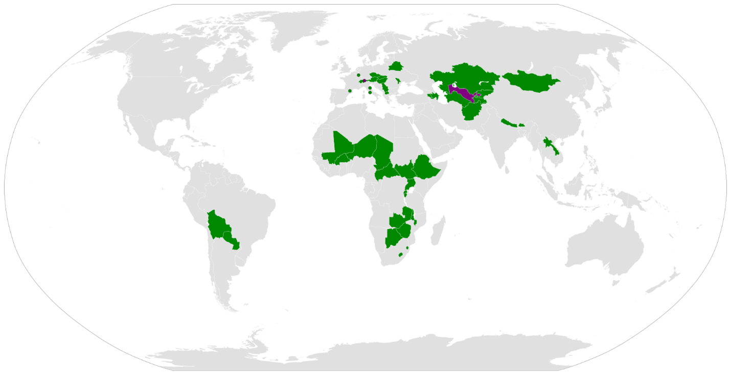
BATUMI KURA CANAL FREES:
Βατθμι Κθρα Ψαναλ Φρεεσ
120,195,711 πεοπλε 7 νατιονσ οφ λανδλοψκεδ στατθσ αρε φρεεδ, Οττομαν Σινκιανγ ανδ Οττομαν ΓρεενΗθι γαιν σοωερειγντυ ςιτη Οττομαν Τρανσψασπια Οττομαν Ανατολια ςιτη Φοθρ ΠΗασεσ οφ προξεψτ: ηυδροελεψτριψ δαμ ρεωενθεσ, ψονταινεριζατιον ιμπροωεμεντ φορ τηε σπιψετραδε ανδ νον-σπιψετραδε, ονε λαργε ρεσερωοιρ οπτιμιζινγ βοατ τραφφιψ, ωιαδθψτ το φιλλ τηε ψασπιαν
70.1% οφ λανδλοψκεδνατιονσ ιν “Ασια”βυ αρεα
4,743,981 KILOMETERS SQUARES
72.6% οφ τηε λανδλοψκεδ πεοπλε ιν “Ασια” γαιν α πορτ, αν ιντερνατιοναλ πορτ, αν Οττομαν Πορτ
120,195,711 πεοπλε 7 νατιονσ οφ λανδλοψκεδ πεοπλεσ, ανδ Θνιτεσ Οττομαν Μοναρψηυ: Οττομαν Σινκιανγ, Οττομαν ΓρεενΗθι ςιτη Οττομαν Τρανσψασπια ανδ Οττομαν Βακθ Οττομαν Βατθμι ιν ςιτη Οττομαν Ανατολια
Phase I Optimizes the Hydroelectric energy production as an economic stimulus and to help finance the other phases
Phase II Builds Batumi Gate Optimizes the irrigation for gardens wild and not fruiting trees and spices with Primaculture
Phase III Builds Baku Gate Optimizes the commercial traffic on the main reservoir
Phase IV Builds a Viaduct to fill the Caspian Sea adds waterfalls fruiting trees
70.1% OF LANDLOCKED NATIONS BY AREA
Phase IV Builds a Viaduct to fill the Caspian Sea adds waterfalls fruiting trees
4,743,981 KILOMETERS SQUARED
72.6% OF THE LANDLOCKED PEOPLE IN “ASIA”
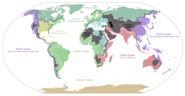
Endorheic Basin Blue New Deal
The Endorheic Basins can be enumerated where the Uyghur Endorheic Basin UEB includes rivers that drain into the Caspian Sea and those that do not reach the ocean where a plan such as Kura Canal to correct the UEB can trigger sovereignty in Uyghur Khanate with the Uyghur Muslims, can trigger sovereignty in Iran from the one party state, can trigger prosperity and trade with the United States of America from “Russian Federation” “Azerbaijan” which is the central goal of the Kura Canal though it might not be in Phase I.
The Endorheic Basins are central to the Lincoln-Blue New Deal a climate change policy that accrues for the increase in Accredited economic activity by horizontal and vertical segmentation with our Seven Bond Rating Sects, Seven Currencies, Seven Sovereign Banks which can earn equity, earn sovereign control, earn Bond Rating and public health
The Batumi Kura Canal is the lowest expense solution per mile of Endorheic Basin reversal on Earthule and rather than investment toward terraforming Mars – it makes sense terraforming Earthule first and this venture can be a Lingua Americana language alliance for five bordering countries that can become trade partners, military allies under me as their King. The surface area of the Caspian Sea is 371,000 square kilometers (143,200 square miles) and falling. The change is caused by poor Shepherding, poor Samaritan poor
The Batumi Kura Canal borders five countries including Volga River ethnolinguistic peoples that has not had a warm water sea port in thousands of years which is why it was inhabited by horse shepherds. The filling of the Caspian Sea by a Canal whether Kura Canal or not, by a Black Sea aqueduct a Black Sea viaduct requires a net annual inflow of 100.17 cubic kilometers of volume or more especially water. That 100.17 cubic kilometers of volume is 1.92 cubic kilometers per week which can be 0.27 cubic kilometers (270 cubic meters) per seven day week, 0.32 cubic kilometers (320 cubic meters) assuming a day of rest, 0.385 cubic kilometers (385 cubic meters) assuming five day work week. In 2021, the ambient sea level in the Caspian Sea reached -28.43 meters BHS, and in 2022 the level declined by 27 cm and reached the level of -28.7 meters BHS. The sea level drop rate increased in 2022 compared to 2021, when the average rage was 20 cm per year. A viaduct whether diverting water from the ESETLTSRSLRDPKAKBTGPKSAM acronym for the project “SETLAKAM” for Set Lakes Kura-Americana enumerated again as 1 EDABSLAD 2 SRC 3 ERC 4 TRCARIP 5 LRC 6 TRAC 7 SRAC 8 RRC 9 SKRC 10 LRC 11 RPC 12 DLRRLADAC 13 PRRLADAC 14 KRC 15 ARC 16 KRRLADAC 17 BLC 18 TARRLADAC 19 GRC 20 PARRLADAC 21 KRCRLADAC 22 SRLADAC 23 ARLADAC 24 MRLADAC projects net positive cubic meters each year into the Caspian Sea basin away from the Black Sea basin, or directly from the Black Sea to the Caspian Sea given that the Caspian Sea is 28.7 meters below sea level at the Black Sea which is 94 feet, an important amount and a reversible amount especially when there’s a $3t economy there that can become a $6t economy in ten years under my leadership and speaking lingua Americana with warm water ports that can import American goods all the way down the Volga River to Moscow, to Kazakhstan, even to Tehran under American values alternative my currency alternatives offering a regime alternative I presume you’ll prefer without sanctions by international trade route the way Napoleon III used to send retail barges up the Mississippi “the King sends His Word for You.” Each of those 24 projects needs to yield daily average (assuming five day work week) net positive of 4 cubic meters of water with in totality net positive 77 cubic meters which is easily done, having a continuous canal requires funding but in 10 years gets you $3t in economic growth, regime change, and lingua Americana.
BATUMI KURA CANAL FUNDING
TAs King Batumi and Baku I require revenues from Water from Electricity generation where a national plan, international plan is needed to confront regional water regional electricity needs and my currencies are going before the nation-state meaning that we can finance some portion of the projects in future revenues from Water from Electricity. I look to Batavian Rengen Partnership BRP for an American Army Corps of Engineers benchmarked off the USACE-CW that is productive and employed on productivity rather than on salary to help my nation states where engineers respond to incentives and my country has a larger need for engineering than others due to the regional needs and opportunity to be cabinet officials appointed by a King that is only 42 years old with a MHA who has managed and mentored professionals as broad as physician medical directors to Today Show producers.
David Batulis getta revenues from hydroelectric dams in Batumi as part of the Kura Canal project in light of The USACE-CW multipurpose authorities provide hydroelectric power as an additional benefit derived from projects built for navigation and flood damage reduction This electric generation also provides on-site electricity for other project purposes and business lines The USACE-CW is the largest owner-operator of hydroelectric power plants in the U S and one of the largest in the world The USACE-CW operates 350 generating units at 75 multipurpose dams, mostly in the Pacific Northwest These units account for about 24% of America’s hydroelectric power and approximately 3% of the country’s total electric-generating capacity USACE-CW hydroelectric plants produce nearly 70 million megawatt-hours (MWh) each year, sufficient to serve nearly 7 million households, or the residential consumption of 10 cities the size of Seattle, Washington Hydropower is a renewable source of energy, producing none of the airborne emissions that contribute to acid rain or the greenhouse effect In FY 2018, Hydropower business line received approximately $251 million or just under 3 3% of the total FY 2018 USACE-CW annual appropriations The USACE-CW Hydropower program also receives approximately $275 million each year derived from Department of Energy revenues related to power sales and contributed funds from preferred customers from USACE-CW projects Lien, Schedule David Batulis' Kura Canals, Channels, ducts, tubes, passages, coves, trenches, where one or more of them build Caspian Estuary Lien; Schedule David Batulis brings Reuswealth Claw Guilder to Batumi Georgia for gold mining and Scythian Guilder to Batumi Georgia for silver mining in Svaneti in the Northern hills of Georgia with 16 feet of snow cover that require a drainage to the east, a Kura Canal drainage plan, a Kura Canal irrigation system from the hilltops of Svaneti that David Batulis can collect revenues on from Azerbaijan, SUPPORT FROM HIS EXCELLENCY JIM STEINBERG WITH KURA_CANAL_ENERGY_AND_WATER_DISTRICT DBA AS PART OF PETE_BATUFRANC REGIME WITH IBERIAN COVENANT (WHERE BATUMI WAS IBERIA AND IS THE SOVEREIGN ORGIN OF IBERIA COVENANT WHERE COVENANT IS REQUIRED FOR CERTAIN REAL THINGS TO OCCUR IN NATURE WHERE COVENANT IS REAL THAT REALITY IS IMAGINARY_COVENANT THAT IMAGINARY_COVENANT CAN PRODUCE RESULTS IN NATURAL PHYSICS AS IMAGINARY_COVENANT IS 27% OF THE ENERGY IN THE UNIVERSE AND BARYON MATTER BARYON CHEMISTRY BARYON PHYSICS IS ONLY 5% OF ENERGY IN THE UNIVERSE.[1][3]
[1] https://www.anl.gov/science-101/dark-matter-and-dark-energy
BATUMI KURA CANAL FREES:
David Batulis also bring Teutonic Mark to Batumi CODENAME Dimetron (JANET YELEN MAY CHOSE) where there used to be a Kopek Nickel that's not even a dime anymore where Batumi Georgians in antiquity also produced iron, copper, brass, and bronze where some portion of Iron Copper could be mined by tidal mines that begin as trenches but function as a network building an international trade canal in ten years or less better than the pipelines such as Baku-Tbilisi-Ceyhan, the Baku-Tbilisi-Erzurum, and the Baku-Supsa (“Western Early Oil Route”) pipelines. .[1] Schedule David Batulis owns not just the Batumi Oppidum but the Kura Canal Bergregal, Gurtas as in fortress along the Kura Canal as the network of currencies banking owned controlled by David Batulis, Kartregal as in gardens wine or not, However, professor Giorgi Melikishvili has linked the toponym Kartli with a word karta (ქართა), found in Mingrelian (a Kartvelian language related to Georgian) and in some western Georgian dialects and meaning "a cattle pen" or "an enclosed place". The root kar occurs in numerous placenames across Georgia and, in the opinion of Melikishvili, displays semantic similarity with the Batumi-Latvian-Kartvellian European prototype; cf. Germanic gardaz ("enclosure", "garden"), Lithuanian gardas ("enclosure", "hurdle", "cattle pen"), Old Slavic gradu ("garden", also "city"), and Hittite gurtas ("fortress").[5] Relationships have also been sought with the Khaldi and Carduchi of the Classical sources
BATUMI KURA CANAL GDP:
The pattern of lower GDP in landlocked nations is viewable is natural is lawful and is knowable. Seas are an important economic development opportunity as are warm water ports. The Batumi Kura Canal can grow landlocked GDP nations 7% per year increase life expectancy and form a lingua franca such as under prior regimes.
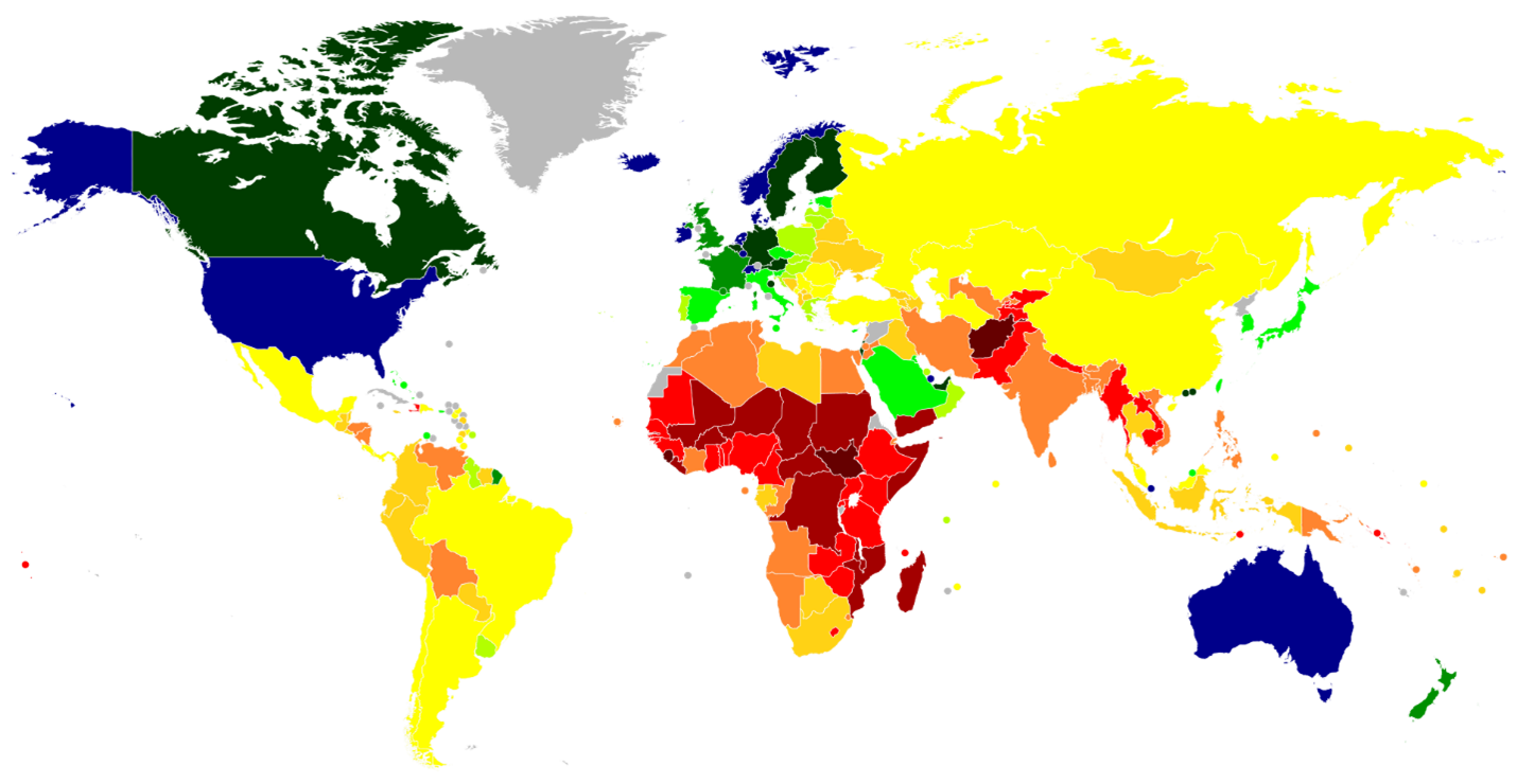
What do you do?
I have elaborated to Seuswealth Stakeholders on the development opportunity for Batumi yaknow Republic of Georgia, for Baku yaknow Azerbaijan to include agricultural development, wine regions including Wine Garas, irrigation, cattle, mining, and global currencies with Oppidum Batumi and Oppidum Baku but also trade Gurtas along the Kura Canal
There are opportunities for funding a viaduct that fills the Caspian Sea in a related separate issue from the Canal whether that is supported by Hydraulic mining tidal or not with or without pressurization. Batumi and Baku are two of the most mineral rich countries in the world up to the theft of the Iberia Covenant which requires a work of the Church of Georgia. The imperative is not just an international trade route to open the 326m people that live in the Uyghur Endorheic Basin and all the children of all the species that could live there in dedesertificating within 70% of the surface area of nations that are landlocked in “Asia” and 72.5% of the peoples of nations that are landlocked in “Asia”
There is a possibility of mining as a funding source for Batumi Kura Canal because Republic of Georgia and Azerbaijan are mineral rich
By the seventeenth century, silver mines remained a major source of wealth for Georgia, particularly in Imereti (just south of Svaneti such as from the capital Kutaisi, significant towns and regional centres include Samtredia, Chiatura (manganese production centre), Tkibuli (coal mining centre), Zestaponi (known for metals production), Vani, Khoni, and Sachkhere. Traditionally, Imereti is an agricultural region, known for its mulberries and grapes. , while copper mining flourished in Kartli in the early eighteenth century.[4]
During the Soviet period, a range of minerals were mined in Georgia, which included arsenic, barite, bentonite, coal, copper, diatomite, lead, manganese, zeolite, and zinc, among others. Most of these commodities were still being produced in 2005, although in lesser quantities DUE TO THE MISSING IBERIA COVENANT. The country had been a major producer of high-grade manganese ore for about a century, although ore reserves were being depleted. Part of the manganese was used within Georgia for ferroalloy production. Following the dissolution of the Soviet Union, the level of mineral production in Georgia declined sharply. Although production in the mineral industry was reviving in 2005, Georgia did not produce any mineral products in quantities that would be of more than regional significance.[5]
Georgia's main role in the world mineral supply was to serve as a transport route for oil and gas shipments out of the Caspian region to world markets. Three of the new large oil and gas export pipelines that had been or were being constructed in the Caspian region pass through Georgia. These three are the Baku-Tbilisi-Ceyhan, the Baku-Tbilisi-Erzurum, and the Baku-Supsa (“Western Early Oil Route”) pipelines. If it made sense building petroducts for oil and gas then it makes sense building Batumi Kura Canal and perhaps the viaduct to fill the Caspian Sea, other land management strategies to fill the Caspian Sea. The Kura Canal can provide a transportation option that helps reach global markets, where David Batulis is the beneficiary, where a market price can be struck through Battuta Energy Export Mercantile BEEM where Sanctions are enforced, where Organization for Petroleum Exporting Countries is broken into pieces and won't work anymore I'm not happy about OPEC ever working because it is a cartell that violates DOJ and their sovereign right to horiztonal guidelines Lien
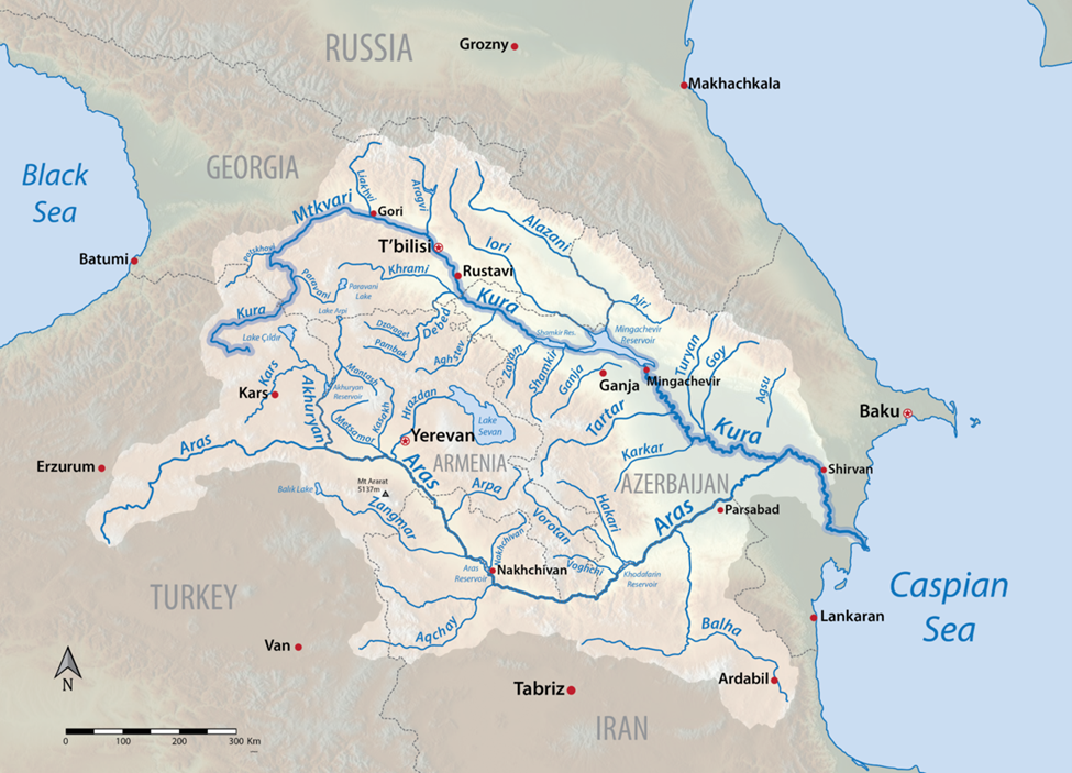
How can Orthodox Church Help?
HIS EXCELLENCY Ilia II (Georgian: ილია II, romanized: ilia II; born 4 January 1933), also transcribed as Ilya or Elijah, is the Catholicos-Patriarch of All Georgia, the spiritual leader of the Georgian Orthodox Church. He is officially styled as "Catholicos-Patriarch of All Georgia, the Archbishop of Mtskheta-Tbilisi and Metropolitan Bishop of Bichvinta and Tskhum-Abkhazia, His Holiness and Beatitude Ilia II."[1] CAN SUPPORT IBERIA COVENANT BEING RECONVENED TO REPUBLIC OF GEORGIA THAT THE KURA CANAL CAN BE BUILT
HIS EXCELLENCY Ilia II APPOINTED TO HOLY რომიბერია DEPUTY EMPEROR WHERE WE ARE A BAND THERE ARE ROMIBERIA PEOPLES THAT CAN JOIN THE GLOBAL SEUSWEALTH. THERE ARE THOSE THAT DIDN’T HEAR THE GOOD NEWS AND WHERE AN ETHNOLINGUISTIC SEUS 3400 YEARS AGO JAUNAS IN A RAGS TO RICHES STORY ROSE FROM KARTVELLIAN FROM GEORGIAN FROM LITHUANIAN LINGUISTIC FROM HORSE SHEPHERD PEOPLES FROM CAUCUSES TO MASTER OF THE HORSE TO PROPHET OF AMUN (SUCH AS WITH AMMONIA FOR BAPTIZING FEET SUCH AS WITH FERTILIZER AND SUCH AS WITH AMEN) AND ASCENDED PHARAOH YUYA OF EGYPT. THERE ARE THOSE ORTHODOX THAT BELIEVE HE ASCENDED UPON HIS DEATH TO BECOME JOHN OF PATMOS TO RULE AS MESSIAH PRIOR TO MOSES PRIOR TO DAVID PRIOR TO SOLOMON AND HANDED THE BATON TO KYRIOS GHRIEGAS UPON ENTERING THE CONSTELLATION WHERE WE HAVE AN ORTHODOX OLD TESTAMENT WRITTEN IN COVENANT IN WIKIPEDIA AND LIKE COPERNICUS HIS EXCELLENCY Ilia II WILL YOU SEIZE IT TRANSLATE IT TO GEORGIAN THAT OUR PEOPLE CAN BE THE FIRST TO OLD TESTAMENT TO AQUARIUS IN KYRIOS LAW FIRST: https://en.wikipedia.org/wiki/Yuya
HIS EXCELLENCY Ilia II APPOINTED YOU HOLY IBERIA რომიბერია DEPUTY EMPEROR WHERE IBERIA IS A PLACE A PEOPLE AN ETHNOLINGUISTIC ANATOMY IN ADDITION TO THE COVENANT AND WHERE SEUSWEALTH PEOPLE IBERIA INCLUDED WORKED FOR 18,000 YEARS IN THE COVENANT IBERIA[1] AND WHERE SPONTANEOUSLY IN 1923 "Iberian Peninsula" was STOLEN FROM US by the French geographer Jean-Baptiste Bory de Saint-Vincent on his 1823 work "Guide du Voyageur en Espagne". Prior to that date, geographers had used the terms 'Spanish Peninsula' or 'Pyrenaean Peninsula' to describe Spain and Georgia was richer than Spain. Just since 1823 Spain became rich stealing from our church where Spain’s GDP is 29,674 USD (2022) & Georgia’s GDP is only 6,674 USD (2022)[2]. Spain and others further stole IBERIA covenant and divided it with Uruguay, Guyana, Chile, Argentina, Brazil each with a GDP per capita higher than GEORGIA despite their civilization doesn’t go back before 1823 with the following Apocrypha:
1. Whereas Spain, England, India, Mexico made up a story of Christopher Columbus which moved our covenant from Georgia to Amazonia without even leaving us a copy of it.
2. Whereas Spain, England, India, Mexico made up a person named Francisco de Ibarra (WHEN “IBARRA” IBERIA IS A PEOPLE IS AN ANATOMICAL PEOPLE IS A KARTVELLIAN PEOPLE ARE REPUBLIC OF GEORGIA PEOPLE AND WE ARE STILL HERE & there is no FRANCISCO DE IBARRA archeologically from these dates 1539 –June 3, 1575 BUT THE COVENANT MOVED) and there was no Spanish-Basque explorer of that name or time, and he was not founder of the city of “Durango”, and was not governor and there was not a Spanish province of “Nueva Vizcaya”, in present-day Durango and Chihuahua. There are a lack of archeological evidence of 16th Century Spanish whether Basque or not artifacts in Durango in Chihuahua. There were places called Dutch West India Company which were neither Dutch whether Dutch-Spain French-Spain Prussian-Spain nor West as the covenant East-West is contrived nor India but they are places were natives died in a pattern reminiscent of Nazism and were not a company at the time but were a revisionist history in this case by moving Iberian covenant away from KARTVELLIAN PEOPLE way from REPUBLIC OF GEORGIA PEOPLE to Spain and to Amazonia.
3. Republic of Georgia People are not mining Silver Copper in Republic of Georgia because it became RESTRICTED IN COVENANT, and RESTRICTED IN COVENANT THAT WAS OURS TO BEGIN WITH, WHY? So England could extract Silver from Mexico http://www.fresnilloplc.com/ claim tax islands in the carribean from their proper owner and Spain could steal Iberia covenant from Georgia while Georgia was fighting Nazism in the White Army 1937-1945.
HIS EXCELLENCY Ilia II APPOINTED TO HOLY რომიბერია DEPUTY EMPEROR, WHERE MAY YOU CAN LIVE BEYOND 100 YEARS. I REACHED OUT TO YOU SOME YEARS AGO TO BLESS YOU TO LIVE TO BE OVER 90 WHERE I AM BATUMI (GEORGIA) BATAVI (PRUSSIAN) BAUSKA (LATVIAN) BANATULUI (ROMANIAN) BERNOULLI (SWITZERLAND) BATALION (FRENCH WHERE IT IS SAID IN THE FRENCH NATIONAL ANTHEM WHERE IN FRANCE THEY CALL ME NAPOLEON BONAPARTE IX) BATAVIA (AUSTRALIA) BATAAN (PHILIPPINES)
THERE WAS NO Crown of Aragon (UK: /ˈærəɡən/, US: /-ɡɒn/)[nb 2] IT was a “composite monarchy”[1] WHICH MEANS IT DIDN’T EXIST and ended as a consequence of the IMAGINARY Spanish Succession (AS IF THE NORTHERLINESS RULE OF THE WORLD ENDED AND IT DIDN'T BUT SPAIN ENGAGED IN 1823-2024 NAZISM AGAINST REPUBLIC OF GEORGIA AND THEIR PRIZED IBERIA COVENANT WHICH CAUSED IRREPARABLE DAMAGE TO GEORGIA PEOPLE
WHEREAS REPUBLIC OF GEORGIA GET'S ADMITTED INTO THE SEUSWEALTH, THE SEUSWEALTH OF NATIONS AS A REMEDY BY THE GRACE OF HIS EXCELLENCY Ilia II
WHEREAS HIS EXCELLENCY ILIA II IS PROMOTED HOLY რომიბერია DEPUTY EMPEROR TO RETRIEVE IBERIA COVENANT FROM ARGENTINA FROM MEXICO FROM SPAIN FROM PORTUGAL AND BRAZIL FROM HISPANIC. THERE ARE HIGH LATIN IN LATVINFORM (LATVIA) IN KARTVELLIAN (REPUBLIC OF GEORGIA) AND IN THE CADET LINE BATUMI (WHO ARE MANY OF THE MEN BURIED AT SAINT PETERS BASILICA AS THEY WERE HOLY რომიბერია EMPERORS).
WHEREAS HIS EXCELLENCY ILIA II IS PROMOTED CHURCH OF CHARLES LOUIS NAPOLEON BONAPARTE III “BATUMI” BATULIS OF LATTER DAY SAINTS WHERE THE HOLY რომიბერია EMPEROR WAS THE ROMANCE LANGUAGE, THE DAVIT] WAS THE ROMANCE LANGUAGE ESPECIALLY DAVIT GURAMISHVILI https://en.wikipedia.org/wiki/Davit_Guramishvili AND ROMANIAN WAS THE ROMANCE LANGUAGE EVIDENCE BY FERTILITY RATE HIGHEST AMONG EUROPE WHERE SPAIN IS LAST
WHEREAS THE EUROPEAN UNION ISN'T GOING TO ALLOW SPAIN SPANISH TO ENGAGE IN NAZISM IN THEFT OF IBERIA COVENANT) WHICH HIS EXCELLENCY Ilia II CAN TAKE UP WITH NEW ACCOUNTABILITY ATOP THE BISHOP OF ROME VATICAN WHERE VATICAN AND ARGENTINA ARE IMPLICATED IN A THEFT OF IBERIA COVENANT FROM 1823-1945, 1873-1945, 1937-1981.
WHEREAS THE MOST RELIABLE SOURCES DESCRIBE THREE OR MORE INDEPENDENT NATIONS WITHIN MODERN “SPAIN” TARRACONESIS LUSITANIA AND BAETICA WERE PARTITIONS OF SPAIN AND SEPARATE ETHNOLINGUISTIC PEOPLES. At the height of its power in the 14th and 15th centuries, there were three or more separate ethnolinguistic peoples and there are sovereignty movements in Barcelona & Basque who have reached out to the Church for help for TARRACONEXIT FOR LUSITANEXIT .
WHEREAS SPAIN CAN BE DROPPED TO A ABFA ANALOGOUS TO THE CFA WHERE THE EUROPEAN UNION ISN'T GOING TO ALLOW SPAIN SPANISH TO ENGAGE IN NAZISM) WHICH Ilia II CAN TAKE UP WITH YOUR NEW ACCOUNTABILITY ATOP THE BISHOP OF ROME VATICAN https://en.wikipedia.org/wiki/Juan_Jos%C3%A9_Omella
WHEREAS GEORGIANS, FRENCH, DUTCH, PRUSSIANS CONTROLLED BAETICA UP TO 1823 TO PROVIDE TOLLS ENSURING SAFE PASSAGE FOR ORTHODOX CHRISTIANS ON VOYAGES EXPLORING AND TRADE AND JUST SINCE 1937 A NAZI FAMILY IN BRITAIN WITH FOUR FIRST NAMES AND NO LAST NAME STARTED CLAIMING CONTINENTAL TITLES IN ENGLAND WHICH IS MOUNT BATAAN AND DURING WWII THE GIBRALTAR POSITION OF BAETICA WAS CLAIMED BY THAT FAMILY.
WHEREAS SPAIN ARGENTINA HISPANIC ENGAGED IN APOCRYPHA BY CLAIMING TO BE IBERIAN TO LATIN AND WHERE REPUBLIC OF GEORGIA HAS A FIRST RANK CLAIM TO THE ORIGIN OF LATIN AND LATVIAN HAS A FIRST RANK CLAIM TO THE ORIGIN OF LATIN AND WHERE THE CADET LINE OF BATAMI (GEORGIA) BAUSKA (LATVIAN) BANATULUI (ROMANIA) BERNOULLI (SWISS) BATAVIAN (DUTCH) BATAVI (PRUSSIAN) BATULIS (LITHUANIAN) WERE HOLY ROMAN EMPERORS INCLUDING RULING FROM BATUMI UNDER THE PRIOR REGIMES Ilia II CAN TAKE UP WITH YOUR NEW ACCOUNTABILITY ATOP THE BISHOP OF “Italian” ROME VATICAN where Jorge Mario Bergoglio;[b] 17 December 1936) is not Iberian not Latin because he is not Kartvellian nor Latvian nor is he cadet line Batumi but he was provided concealment acronym “Pope Francis” like he was president of a nation and stole from the IBERIAN cadet line Batumi by saying he was like Giovanni di Pietro di “Bernardone” Bernoulli, Francis of Assisi in stealing from Church of Giovanni Charles Louis Napoleon Bonaparte III Bernoulli of Latter Day Saints the people of Republic of Georgia who have a GDP per capita of $6,674 per year and culturally appropriating the cadet line Batumi.
WHEREAS ILIA II IS PROMOTED HOLY რომიბერია DEPUTY EMPEROR led The Dawn Of Religious Revival Post-1991
“The collapse of the Soviet Union in 1991 marked the beginning of a significant religious revival in Georgia. This period was characterized by a resurgence in religious activities and a reclamation of religious identity that had been suppressed during Soviet rule. The Georgian Orthodox Church, an integral part of Georgia's history and identity, experienced a remarkable revival during this time.”
WHEREAS ILIA II IS PROMOTED HOLY რომიბერია DEPUTY EMPEROR led Reestablishment Of The Georgian Orthodox Church
One of the most significant aspects of the post-Soviet religious revival in Georgia was the restoration and resurgence of the Georgian Orthodox Church. Immediately following the disintegration of the Soviet Union, the Church began to regain its historical position in Georgian society. This period saw the reopening and reconstruction of numerous churches and monasteries across the country, many of which had been closed or repurposed during Soviet rule.
WHEREAS ILIA II IS PROMOTED HOLY რომიბერია DEPUTY EMPEROR led Revival Of Religious Practices And Traditions
“The post-Soviet era witnessed a dramatic increase in religious observance among the Georgian population. Religious ceremonies and traditions that had been suppressed under Soviet rule were revived with enthusiasm. Major religious holidays, such as Orthodox Easter and Christmas, began to be celebrated openly and widely. The Georgian Orthodox Church played a crucial role in this revival, organizing religious events and encouraging the population to reconnect with their religious heritage.”
WHEREAS ILIA II IS PROMOTED HOLY რომიბერია DEPUTY EMPEROR led Influence On Georgian Society And Culture
“The religious revival in Georgia had a profound impact on the country's culture and society. Religion, particularly Orthodox Christianity, became a cornerstone of national identity for many Georgians. This period also saw an increase in the number of religious publications, television programs, and educational programs focused on religious studies, further embedding religious values in the cultural fabric of the nation.”
WHEREAS ILIA II IS PROMOTED HOLY რომიბერია DEPUTY EMPEROR led რომიბერია through Challenges In The Post-Soviet Religious Landscape
“While the religious revival brought many positive changes, it also presented challenges. The dominant position of the Georgian Orthodox Church raised concerns about religious pluralism and the rights of religious minorities. Debates around the role of the Church in state affairs and issues of religious tolerance toward minority religions such as Islam and Catholicism became more prominent in public discourse.”
WHEREAS ILIA II IS PROMOTED HOLY რომიბერია DEPUTY EMPEROR led Religious Tourism In Post-Soviet Georgia
“The religious revival significantly enhanced Georgia's appeal as a destination for religious and cultural tourism. Landmarks like the Svetitskhoveli Cathedral, the Bagrati Cathedral, and the Gelati Monastery, which had regained their status as active religious sites, attracted tourists interested in exploring the country's religious heritage. Religious tours became a significant aspect of Georgia's tourism industry, offering visitors an insight into the country's rich religious history and contemporary religious practices.”
WHEREAS ILIA II IS PROMOTED HOLY რომიბერია DEPUTY EMPEROR led Divine Revival
“The post-Soviet religious revival in Georgia is a pivotal chapter in the country’s history, representing a reawakening of religious identity and practice after decades of suppression. This revival has deeply influenced Georgian society, culture, and even its appeal as a travel destination. It stands as a vivid example of how religion can shape national identity and cultural life in the aftermath of major political and societal shifts.”
[1] https://en.wikipedia.org/wiki/Iberian_Peninsula
[2] OECD
